[CalWild] – The California Wilderness Coalition applauds Rep. Judy Chu for introducing legislation to protect more than 31,000 acres of Wilderness and nearly 46 miles of Wild and Scenic Rivers in southern California’s San Gabriel Mountains.
The bill, which protects wild places within the San Gabriel Mountains National Monument and the Angeles National Forest, is another step towards securing permanent protection for federally managed public lands that provide the “backyard” to the Los Angeles urban area. Rep. Chu helped convince President Barack Obama to establish the San Gabriel Mountains National Monument in 2014. Earlier this year, she introduced legislation in Congress to expand the National Monument and to establish the San Gabriel River National Recreation Area on public lands downstream of the Monument in the San Gabriel Valley. This new bill will ensure that pristine and undeveloped areas are permanently protected for present and future generations.
“The San Gabriel Mountains Forever Act has been decades in the making,” said Chu when she introduced the bill. “Wilderness designation ensures that the wildlife and rivers within the Monument will remain unchanged for generations. This designation is especially critical for protecting our drinking water, much of which comes from these mountains,” she said.
The legislation proposes to add 13,851 acres to the existing Sheep Mountain Wilderness and 2,027 acres to the San Gabriel Wilderness. It establishes two new areas – the 8,417-acre Condor Peak Wilderness and the 6,774-acre Yerba Buena Wilderness. The bill also protects as Wild and Scenic Rivers more than 25 miles of the upper segments of the East, North, and West Forks of the San Gabriel River, and 20 miles of Little Rock Creek.
Wilderness and Wild and Scenic River designations provide the highest level of protection for wild places on federally managed public lands. New road construction, logging, and energy development are off limits in Wilderness, while hiking, fishing, and hunting are allowed. New dams are prohibited on Wild and Scenic River segments and the managing federal agency is required to protect the free-flowing character and outstanding values of designated rivers.
“These precious wild places provide 30 percent of Los Angeles County’s clean drinking water and 70 percent of the open space in California’s most urbanized county,” said Linda Castro, CalWild Assistant Policy Director. “The mountains and streams proposed for protection in this bill are home to dozens of rare, threatened, and endangered animals and plants. They also offer outdoor recreation opportunities for millions of visitors, many of them residing in adjacent park-poor communities,” she said.
Protecting Wilderness and Wild and Scenic Rivers also helps mitigate the damaging effects of climate change by sequestering carbon and nitrogen and by providing multi-elevation migration corridors and refugia for plants and animals whose habitats are increasingly fragmented or degraded by climate change.
In addition to CalWild and its conservation allies, the legislation enjoys atypical support from the San Gabriel Valley Water Association and the local Concerned Off-Road Mountain Bikers Association. Numerous local elected officials, business owners, and community leaders also support protection of wild places in the San Gabriel Mountains. Although the immediate prospect for passage of Rep. Chu’s legislation is uncertain given partisan divisiveness in Congress, the unusually high level of public support may make even the current Congress take notice and act on this bill.
CalWild and the local and national groups and activists that make up the San Gabriel Mountains Forever coalition have been working with Rep. Chu and other legislators for more than 10 years to protect the San Gabriel Mountains and its wild places. CalWild took the lead on developing boundaries for the proposed Wilderness and legislative descriptions for the proposed Wild and Scenic Rivers. CalWild also met with numerous water agencies, utilities, and local elected officials to secure support.
Wild Places Proposed for Protection in Rep. Chu’s San Gabriel Mountains Forever Act:
Sheep Mountain Wilderness Additions
13,851 acres in the San Gabriel Mountains National Monument
The proposed Sheep Mountain Wilderness additions encompass several tributary canyons of the San Gabriel River, the San Gabriel Mountains crest between Mt. Baden Powell and Mt. Hawkins that includes the Pacific Crest Trail, and a portion of the Blue Ridge and upper Prairie Fork San Gabriel River watershed. The Pacific Crest Trail segment protected in the bill was described by the Los Angeles Times as one of the most scenic segments of the 2,638-mile long trail. The additions also include a portion of the popular East Fork Trail, described in the definitive guidebook Trails of the Angeles as offering “nature in its grandest proportions.” The additions provide habitat for the endangered mountain yellow-legged frog, Nelson big horn sheep, California spotted owl, and the San Gabriel Mountains slender salamander. Most of the Sheep Mountain additions were recommended for wilderness protection by the Forest Service.

San Gabriel Wilderness Additions
2,027 acres in the San Gabriel Mountains National Monument
The proposed San Gabriel Wilderness Additions encompasses much of the western slope of the North Fork San Gabriel River canyon and a portion of the upper West Fork San Gabriel River. The Forest Service identified much of this addition as an area of high ecological significance because it supports the region’s largest and most continuous stands of bigcone Douglas fir and because it provides critical habitat for the Nelson big horn sheep and San Gabriel mountain salamander. The proposed wilderness addition is virtually trail-less, offering a true primitive adventure for visitors with good stamina and wilderness skills. Several streams flowing from the proposed wilderness addition are important sources of fresh water for the North and West Forks of the San Gabriel River.
Condor Peak Wilderness and Yerba Buena Wilderness
8,417 acres and 6,774 acres (respectively) on the Angeles National Forest
The proposed Condor Peak and Yerba Buena Wilderness areas are divided by a narrow mountain bike trail corridor. The two areas encompass several canyons and creeks tributary to and north of Big Tujunga Canyon. The entire area is dominated by Condor Peak, a mountain favored by the endangered California condor for its thermals. The peak also looms over the rugged and perennially flowing Trail Canyon Creek. The definitive trail guide to the San Gabriel Mountains, Trails of the Angeles, describes the creek as a “lush and verdant oasis in the semi-arid front country of the San Gabriels.” The trail leads hikers to the 30-foot high Trail Canyon Falls. East of Condor Peak, the trail-less Fox Creek offers its own secret waterfalls. The entire area is an important contributor of fresh water to Big Tujunga Canyon, which supports several threatened and endangered species and was identified by the Forest Service as an area of high ecological significance.
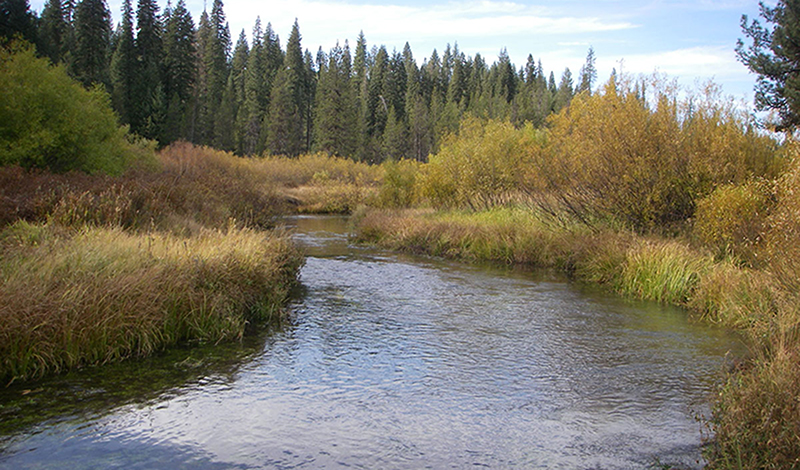
San Gabriel Wild and Scenic River (East, West, and North Forks)
25.3 miles of river in the San Gabriel Mountains National Monument
The East, North, and upper West Forks of the San Gabriel River drain the largest watershed in the San Gabriel Mountains and provide thirsty downstream residents with clean drinking water. All three forks were identified by the Forest Service as areas of high ecological significance and were determined eligible for National Wild & Scenic River protection for their outstanding fish, scenic, recreation, and historical values. The East and North forks support the best habitat and best remaining population of threatened Santa Ana sucker and a rare assemblage of other native fish species. The road accessible portions of all three forks are popular destinations for thousands of visitors who picnic, wade, camp, hike, and fish these streams. The upper West Fork can be explored via the Gabrieleno and Silver Moccasin National Recreation Trails, which access several primitive camps along the stream. According to Trails of the Angeles, the upper West Fork “is a delight to anglers, campers, and hikers alike…It offers woodsy haunts and streamside solitude to any who will seek these qualities.” The East Fork leads into the Sheep Mountain Wilderness, providing unique opportunities for southern California residents to enjoy peace and solitude along a year-round flowing stream. Historic mining sites on the East Fork provide an important record of this activity, which provided the impetus for the exploration and settlement of the San Gabriel Mountains.
Little Rock Creek Wild & Scenic River
20.2 miles of stream in the San Gabriel Mountains National Monument
Rising from the sub-alpine slopes of Mount Williamson on the Angeles Forest, Little Rock Creek tumbles down from the northern escarpment of the San Gabriel Mountains into the Mojave Desert. The upper segment of the creek is in the Pleasant View Ridge Wilderness (established in 2009) and supports an important population of endangered mountain yellow-legged frog. Further downstream, the creek supports one of three known populations of the endangered arroyo toad on the Angeles Forest. The entire creek was identified by the Forest Service as an area of high ecological significance and an eligible National Wild & Scenic River due to its outstanding wildlife values. The diverse high country and desert scenery through which the creek flows attract visitors for picnicking, water play, and hiking. Both the Pacific Crest Trail and the High Desert National Recreation Trail wind their way along and across the upper reaches of the creek. Little Rock Creek and its upper tributaries, Cooper and Buckhorn Canyons, are described in Trails of the Angeles as “three of the most delightful sylvan recesses in Angeles National Forest.” The trail from Buckhorn Canyon to Little Rock Creek is considered “one of the best in the San Gabriels.” Expert kayakers have been known challenge the class V-VI whitewater of Little Rock Creek, navigating its stunning cascades all the way from the high country to the desert.
Like this:
Like Loading...
Related


 Tweet This
 Facebook
 Digg This
 Bookmark
 Stumble
 RSS
RSS


REAL NAMES ONLY: All posters must use their real individual or business name. This applies equally to Twitter account holders who use a nickname.
2 Comments
Where is this in the Angeles Forest?
That would be 10k+ acres in the first two areas of the east San Gabriel river, along with another 25.7 miles of that river and it’s creek beds. In the last area, it would only affect the Littlerock Creek area – that would be in the northern San Gabriel Mountain watershed. Unfortunately, the article didn’t supply enough data to compare them.
I have intimate knowledge of Littlerock Creek and I can tell you that anybody who tries to kayak down that expanse in an average summer will be dry-hauling his canoe a long damned way. Probably with some serious dings as well. These are typically spring flow creeks, and by summer they are trickles at best.
Of course, they are probably including the dam outflow from Littlerock Creek since outside of recent winter rains, that sucker is dry most times. What water comes out of Littlerock dam is sent to Palmdale reservoir as part of the local water/aqueduct system.
The Littlerock Creek watershed is not a wild and scenic river; it is part of the local economy’s necessary water sources in the Littlerock and AV areas.
As long as you agree with fencing off and preventing access to these areas, you should be happy about this new federal taking.
Personally, I’d really like to be able to go up to Littlerock Creek on a backpack trip and camp out alongside the creek. Like I did 25 years ago. Except for one thing – all those times I was there from 1964 to 1987, there wasn’t enough flow to float a single kayak for more than 100 yards. Until after the dam that is.