header image

[Sign Up Now] to Receive Our FREE Daily SCVTV-SCVNews Digest by E-Mail

Inside
Weather


Calendar
Today in
S.C.V. History
April 24
1962 - SCV residents vote to connect to State Water Project, creating Castaic Lake Water Agency (now part of SCV Water) [story]
Castaic Lake


Commentary by Mike Summe
| Thursday, Oct 27, 2016

mikesummeWhen I moved to California in 1977, I settled in the flatlands of the L.A. basin and stayed there for the next 35 years, paying scant attention to the mountains. In 2012, I retired and started hiking and biking into the mountains that separate my home in Shadow Hills from Santa Clarita. I kept running into strange, fenced-in sites, usually located at the top of cul-de-sacs.

Each site consisted of a pit that ended at a concrete wall. Close to the wall, a strange perforated silo would rise up. On the locked gates hung two signs. One warned against trespassing. The other declared the site was under the control of the Los Angeles County Department of Public Works and gave what appeared to be the name of the site — often the name of the street followed by the abbreviation “D.B.”

It turned out that “D.B.” means “debris basin.” There are 172 in Los Angeles County, including 33 in the Santa Clarita Valley. My purpose here is to share some basic facts about these important structures and give you some leads if you’d like to do some exploration of your own.

What is a debris basin? One website (www.fws.gov) defines a debris basin as a “specially engineered and constructed basin for storing large amounts of sediment moving in an ephemeral stream channel.” The DPW provides a more helpful definition: “Debris basins are instrumental components of the flood control system. Typically located at the mouths of canyons, debris basins capture the sediment, gravel, boulders, and vegetative debris that are washed out of the canyons during storms. The debris basins capture the material and allow the water to flow into the downstream storm drain system.”

debrisbasin02Each debris basin typically consists of an excavation that begins at the bottom of a canyon and terminates at a dam. Near the dam is a “perforated silo” made of corrugated metal, sometimes concrete. The DPW calls these silos “the outlet works.” Their purpose is to allow the water to flow past (under) the dam, even when a considerable amount of debris has accumulated in the basin. The paved spillway on the downhill side of the dam helps control the water that flows under or, on occasion, over the dam.

The debris basins may also contain a number of less visible features including a porous basin that allows water to soak into the ground and a well that stores water that can later be pumped into the public water supply. In the hills above the debris basins, one may find check dams and other structures that direct water into the canyon.

Not all debris basins have all of these features; the oldest ones didn’t separate the water from the debris. As for size, most debris basins “are associated with small catchments and … are commensurately modest, with capacities under 100,000 cubic yards.” The smallest one I’ve seen is the Camp Plenty debris basin in Canyon Country; a larger, more complete one is the Wedgewood debris basin in Castaic.

What is the purpose of debris basins? The answer is best explained as the interaction of two inexorable forces. The first is the geology of Los Angeles. The mountains that dominate our landscape are among the youngest and most rapidly rising on Earth and the most unstable. As John McPhee points out in his well-known essay, “Los Angeles Against the Mountains,” the San Gabriel Mountains are “shedding, spalling” and “disintegrating at a rate that is … among the fastest in the world.” The second inexorable force is people. Los Angeles County has a population of more than 10 million, and we all know that more and more houses are being built in the mountains and foothills. There are plenty of recent examples in the Santa Clarita Valley.

What happens when these two forces interact is explained by the DPW: “Although the weather in Southern California has often been described as the best to be found anywhere, it is capricious and capable of producing enormous flood devastation. Storms, moving in from the Pacific generally from October to March, come up against the numerous steep mountain ranges that ring Malibu, the Los Angeles Basin, and the Antelope, San Fernando, San Gabriel and Santa Clarita Valleys. These storms frequently produce enormous amounts of runoff that spill out onto the flatlands leading to the Pacific Ocean or Mojave Desert. And if the age-old fire sequence has occurred along the hillsides during the dry months, the rate, composition and amount of runoff are substantially increased. Since the geological composition of the mountain ranges erodes quite easily, a heavy mix of debris is added to the descending storm waters.”

John McPhee gives a vivid description of what the DPW calls “a heavy mix of debris.” Debris flows, McPhee explains, “more or less resemble fresh concrete. They consist of water mixed with a good deal of solid material, most of which is above sand size. Some of it is Chevrolet size.” His automotive metaphor is not inappropriate, for in his description of a specific event, he tells how a mudslide “was not only full of boulders; it was so full of automobiles it was like bread dough mixed with raisins.” Making matters worse, the mudslide was fast enough to overtake a number of residents who tried to flee downhill in their cars.

How effective are the debris basins? Although man cannot control the mountains of Los Angeles, John McPhee admits: “Generally, the debris basins work.” But they are not 100 percent effective, and debris basins can and have been overwhelmed – sometimes with catastrophic results. Also, debris basins are expensive – not only to build, but also to maintain.

debrisbasin01To function properly, the debris must regularly be cleaned out, which not only requires expensive contracts, but also raises the question of where the debris goes. It is easiest if the site is nearby, but you probably won’t be surprised to learn this is not always popular with residents. Sometimes the debris, which in the absence of man’s intervention would have washed down to the ocean, is hauled in the opposite direction over the mountains. McPhee explains the irony: “Now there is a beach problem. Sand is being lost to offshore canyons and is not being replenished. … A place that values its beaches as much as Southern California does has no choice but to buy sand.” And people can be picky. “When 30,000 yards of sand was put on Zuma Beach, people complained that it was the wrong color.”

A short history. In the early days, “there was a moat of oranges between the built-up metropolis and the mountain front.” However, when wildfires in late 1913 were followed by heavy rains and a flood in early 1914, it was clear that more protection was needed. The government responded quickly. In 1915, the California Legislature created the Los Angeles County Flood Control District. One of its first projects was the Devil’s Gate Dam, built in 1920 to control the Arroyo Seco. A few years later, nature again delivered its one-two combination. At the end of 1933, wildfires denuded the slopes above Pasadena, La Cañada, La Crescenta and Montrose. Then on New Year’s Day, a “Noah-type storm” struck, mobilizing “a number of almost simultaneous debris flows that came out of the mountains, went through the orchards and into the towns, killed dozens of people, destroyed hundreds of houses, and left boulders the size of icebergs.”

There was ironically an unexpected benefit to this disaster. People noticed that a gravel pit in Haines Canyon above the village of Tujunga had swallowed the debris flow that would otherwise have wiped out the community. According to McPhee, this gravel pit became the inspiration, the model for all debris basins.

Be that as it may, a number of debris basins were built on the southern slopes of the San Gabriels in the aftermath of the 1934 mudslides. On a website maintained by the U.S. Geological Survey, I found the dates of initial operation for 75 of Los Angeles County’s 172 debris basins. Fifteen were built in the immediate aftermath of the 1934 flood, all in the area of that flood. Seven more were built in the 1940s; again, most were built on the south-facing slopes of the San Gabriels in the greater Pasadena area, but one was built as far west as Northridge and another as far east as Brea. Nineteen were built in the 1950s, with most on the south-facing slopes above Foothill Boulevard, but with one in Whittier, one in the Verdugos and a few in the San Fernando Valley. Twenty were added in the 1960s, some in the core area but others extending out to Glendora and one in Newhall — the Wildwood debris basin on Davey Avenue. The USGS website identified 12 debris basins built between 1970 and 1975; however, there was no information for subsequent years, so I do not have operation start dates for the other 97 debris basins.

My guess is that the 97 undated debris basins were built after 1975. Why do I say this? Because the information I do have suggests the building of debris basins occurred in step with the development of housing tracts in or near the mountains. My sense is that the earliest residential development occurred in the greater Pasadena area where the earliest debris basins are located. It also seems that the order in which additional debris basins radiated from Pasadena between 1940 and 1975 follows the same timeline as residential expansion. Many of the undated debris basins are located in areas where large-scale building occurred still later.

To the east, the communities with debris basins for which I have no dates include Monrovia, Duarte, Glendora, Rowland Heights, Diamond Bar; to the west, Canoga Park, Calabasas, Malibu; and to the north, Santa Clarita, Castaic and Palmdale.

As part of my research, I visited five debris basins in the hills along Hillcrest Parkway in Castaic. The neighborhoods are obviously newly built, and at the end of the cul-de-sacs that mark the uphill limit of development, I found the debris basins. My conclusion? They were built contemporaneously with the housing tracts. Am I right? I won’t know for sure until I find the start dates. If anyone can provide me with such dates or point me in the right direction, please send me the information.


Mike Summe is a docent at the Placerita Canyon Nature Center and a retired high school principal.

Comment On This Story
COMMENT POLICY: We welcome comments from individuals and businesses. All comments are moderated. Comments are subject to rejection if they are vulgar, combative, or in poor taste.
REAL NAMES ONLY: All posters must use their real individual or business name. This applies equally to Twitter account holders who use a nickname.

4 Comments

  1. Very interesting Mike. Thanks.

  2. Julio Diaz Julio Diaz says:

    Fantastic read, thank you Mike :)

  3. Great, Mike. Tried to share this in Placerita fb page, failed.

  4. Tina White Tina White says:

    I talk about these in the college geography courses I teach; thank you for an interesting new assigned reading for my students!

Leave a Comment


Opinion Section Policy
All opinions and ideas are welcome. Factually inaccurate, libelous, defamatory, profane or hateful statements are not. Your words must be your own. All commentary is subject to editing for legibility. There is no length limit, but the shorter, the better the odds of people reading it. "Local" SCV-related topics are preferred. Send commentary to: LETTERS (at) SCVNEWS.COM. Author's full name, community name, phone number and e-mail address are required. Phone numbers and e-mail addresses are not published except at author's request. Acknowledgment of submission does not guarantee publication.
Read More From...
RECENT COMMENTARY
Tuesday, Apr 23, 2024
Los Angeles County Fifth District Supervisor Kathryn Barger issued a statement in support of the Los Angeles County Chief Executive Officer’s presentation of a $45.4 billion budget for the forthcoming 2024-25 fiscal year.
Monday, Apr 22, 2024
Recently I had the opportunity, along with spcaLA President Madeline Bernstein and Inland Valley Humane Society & SPCA President Nikole Bresciani, to meet with NBC 4 reporter Kathy Vara to discuss the current challenges facing animal sheltering organizations.
Monday, Apr 22, 2024
As city manager for 12 years now and a longtime resident of Santa Clarita, I am always proud to see how our community continues to grow.
Tuesday, Apr 16, 2024
Supervisor Barger issued the following statement today, after the Board of Supervisors voted unanimously to implement the Rental Housing Habitability Program
Monday, Apr 15, 2024
Cowboy Festival weekend is upon us!
Thursday, Apr 11, 2024
Have you ever wanted to journey to another country to experience an array of new and unique cultures and customs?

Latest Additions to SCVNews.com
1962 - SCV residents vote to connect to State Water Project, creating Castaic Lake Water Agency (now part of SCV Water) [story]
Castaic Lake
Los Angeles County Fifth District Supervisor Kathryn Barger issued a statement in support of the Los Angeles County Chief Executive Officer’s presentation of a $45.4 billion budget for the forthcoming 2024-25 fiscal year.
Kathryn Barger | Statement in Support of $45.4B County Budget
In a celebration held Tuesday, April 23 at the Port of Barcelona, award-winning actress and performer Hannah Waddingham officially welcomed the newest and most innovative Princess Cruises ship, Sun Princess, serving as godmother during a star-studded naming ceremony.
Hannah Waddingham Officially Christens Sun Princess
Six comprehensive high schools in the William S. Hart Union High School District which includes Canyon, Golden Valley, Hart, Saugus, Valencia and West Ranch have been ranked among the top public high schools in the country by U.S. News & World Report.
Hart District High Schools Recognized Best in Nation
College of the Canyons will offer four summer sessions running from June 3 through Aug. 17, giving students a variety of options in both class format and scheduling designed to help them achieve their educational goals, from launching a new career to transferring to a four-year university.
COC Offers Four Summer Sessions for Flexible Learning Options
California State Sen. Scott Wilk, R-Santa Clarita, announced his measure to combat illegal dumping, by increasing penalties and closing a loophole which has enabled the problem for years, was approved in the Senate Public Safety Committee.
Wilk’s Illegal Dumping Bill Approved by Committee
Super Jazz at the Ranch, a daylong jazz festival hosted by West Ranch High School, is happening Saturday, May 18. Music will fill the air as performers from throughout the region showcase their talents.
May 18: Super Jazz Festival at West Ranch High School
California State Assemblywoman Pilar Schiavo, D-Chatsworth, has presented The Healthy Homework Act (AB 2999) to the Assembly Education Committee.
Schiavo Presents Healthy Homework Act to Prioritize Mental, Physical Health
The city of Santa Clarita has notified the public that the playground at West Creek Park, 24247 Village Circle Drive, Valencia, CA 91354, is currently closed for repairs on the rubberized surface.
West Creek Park Playground Closed for Repairs
The Santa Clarita Valley Media Collaborative invites local creatives, media industry professionals, students, parents, teachers and others to celebrate the next generation of media makers participating in the inaugural NextGen MediaMakers Festival on Saturday, May 18 from 2-5 p.m. at the Canyon Country Community Center.
May 18: NextGen MediaMakers Festival Invites Creatives, Students, Experts to Celebrate Media
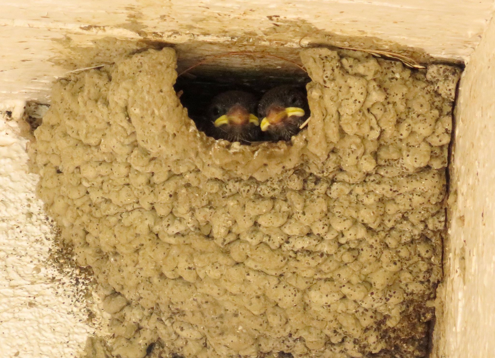
1986 - COC board votes to allow Argentine cliff swallows to nest forever on sides of buildings [story]
swallows
As Volunteer Appreciation Week approaches, the County of Los Angeles Department of Animal Care and Control wishes to extend heartfelt gratitude to all its dedicated volunteers who tirelessly contribute to DACC's mission of advancing the well-being of animals and people in the County.
DACC Pays Recognition to Volunteers
The Canyon Country Farmers Market will be celebrating their two-year anniversary Wednesday, April 24.
April 24: Canyon Country Farmer’s Market Celebrates Two-Year Anniversary
The Henry Mayo Newhall Hospital Auxiliary presented a $35,000 check Monday to the Henry Mayo Newhall Hospital Foundation for the foundation’s Patient Tower Capital Campaign.
Henry Mayo Auxiliary Fulfills $600K Patient Tower Pledge
The Acton/Agua Dulce Arts Council has announced a call for entries for "Creature Feature," a juried art exhibition, with a theme of any living creature.
Entries Needed for ‘Creature Feature’ Art Show
The Acton/Agua Dulce Arts Council has announced a call for entries for a juried exhibit open to all photographers, both professional and amateur.
Acton/Agua Dulce Arts Council Announces Call for Photographers
Recently I had the opportunity, along with spcaLA President Madeline Bernstein and Inland Valley Humane Society & SPCA President Nikole Bresciani, to meet with NBC 4 reporter Kathy Vara to discuss the current challenges facing animal sheltering organizations.
Marcia Mayeda | Current Challenges in Animal Sheltering
As city manager for 12 years now and a longtime resident of Santa Clarita, I am always proud to see how our community continues to grow.
Ken Striplin | Visit Skyline Ranch Park – Santa Clarita’s Newest Amenity
The city of Santa Clarita’s Film Office released the list of six productions currently filming in the Santa Clarita Valley for the week of Monday, April 22 - Sunday, April 28.
Filming in Santa Clarita Includes Six Productions
Henry Mayo Newhall Hospital is recognizing its valued volunteers during National Volunteer Week April 21-27.
Henry Mayo Celebrating National Volunteer Week
The regular meeting of the Saugus Union School District Governing Board will take place Tuesday, April 23, with closed session beginning at 5:30 p.m., followed immediately by public session at 6:30 p.m.
April 23: Saugus Union to Discuss 2023/24 Personnel Report
The Santa Clarita Community College District Board of Trustees will hold a self-evaluation workshop Wednesday, April 24, beginning at 2 p.m.
April 24: COC Board of Trustees’ Self-Evaluation Workshop
A Los Angeles County Sheriff's deputy, who was severely injured in October after an explosion and fire at a Pitchess Detention Center mobile shooting range, died Saturday, LASD announced Sunday.
LASD Deputy Dies Months After Pitchess Shooting Range Explosion
SCVNews.com