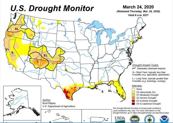
It’s been a dry winter: Much of California remains in abnormally dry conditions and several regions in the northern half of the state are experiencing drought, according to a Thursday report from the U.S. Drought Monitor.
Despite a series of late-season storms giving the thirsty state much needed precipitation during March, it was not enough to make up for the rain and snow deficit run up during the inordinately dry winter.
“While the late-season precipitation has reduced irrigation demands and has provided a nice boost in soil moisture and snowpack, the moisture is generally too late for drought-stressed rangeland that has already lost forage yield potential due to winter drought,” the agency reported.
The latest storms brought the Northern Sierra snowpack to 53% of normal as April 1 approaches. The date is important for water managers because that is when the snowpack in the Sierra Nevada is typically at its peak before it begins to melt and replenish reservoirs throughout California’s complex water system.
The Central Sierra’s snowpack stands at 55% of normal and the Southern Sierra is at 42% of normal.
California’s reservoirs are not yet up to full strength, a foreboding sign for a state that historically draws the lion share of its precipitation during the winter months and stores it for the dry summers.
Folsom Lake, for instance, is at 48% full at present and is at 78% of its historical average. Similarly, Lake Oroville is 64% full currently, 86% of its historic average.
California is set to get another round of precipitation over the weekend, but after that forecasts project clear skies and dry weather.
Still, officials haven’t abandoned hope.
“Right now, 2020 is on track to be a below-average year but we could still see large storms in March and April that will improve the current snowpack,” said Sean de Guzman, chief of Snow Surveys and Water Supply Forecasting Section for the California Department of Water Resources.
The border of Oregon and California continues to be one of the hardest-hit areas in the American West.
“Below-normal seasonal precipitation was reflected by dry soils, sub-par snowpack, and unusually low streamflow,” the monitor said. “Patches of dryness and drought also stretched from the eastern slopes of the Cascades onto the northern High Plains.”
Near all of Oregon and most of central Washington remain categorized in “abnormally dry” conditions or varying levels of drought.
The Four Corners region, where Arizona, New Mexico, Utah and Colorado intersect, continues to be hounded by drought-like conditions.
The area of the country experiencing the worst drought conditions is in Texas, along the Rio Grande and its border with Mexico. But the region enjoyed some rain over the past week, meaning the extent of area categorized as “extreme drought” was reduced since the last report.
Florida makes an unusual appearance on the drought monitor report. Usually replete with rain and moisture, most of the state is experiencing abnormally dry conditions.
“Warm, dry weather dominated the lower Southeast, including Florida, boosting irrigation demands and further reducing topsoil moisture,” the monitor reported. “Weekly temperatures averaged more than 10°F above normal in many areas from the central Gulf Coast into the Southeast, contributing to further introduction or intensification of abnormal dryness (D0) and moderate to severe drought.”
For California, a below-average water year will cause officials to fret. While most of the government’s attention is focused on the escalating coronavirus crisis, a paucity of precipitation could mean an early fire season and water restrictions in a time where people are being encouraged to repeatedly wash their hands.
— By Matthew Renda, CNS
Like this:
Like Loading...
Related


 Tweet This
 Facebook
 Digg This
 Bookmark
 Stumble
 RSS
RSS


REAL NAMES ONLY: All posters must use their real individual or business name. This applies equally to Twitter account holders who use a nickname.
0 Comments
You can be the first one to leave a comment.