By Matthew Renda
The Sierra Nevada snowpack stands at 162 percent of average, California water managers said on Tuesday following the final measurement of the water year.
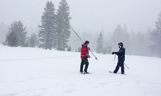
The snowpack measurement – which the California Department of Water Resources conducts around the first of each month of winter at the Phillips Station near Lake Tahoe – demonstrates the spectacular shape of California’s water picture.
“With full reservoirs and a dense snowpack, this year is practically a California water supply dream,” department director Karla Nemeth said in a statement.
And the winter fun isn’t done yet: Forecasts call for another atmospheric river to strike the Golden State on Friday.
Atmospheric rivers are large storm systems with high moisture content created in the Pacific Ocean and can mean the difference between a state replete with water and one dogged by persistent drought.
This winter, more than 30 atmospheric rivers marched through California, six in February alone. The state’s snowpack water content has tripled since Feb. 1.
April 1 is considered by water managers to be the most important of all the snowpack measurement dates because it is right before the snow starts to melt, replenishing they system of reservoirs throughout the late spring and into summer.
On average, the melting snowpack meets about 30 percent of California’s water demands annually, including the irrigation needs of farmers in the Central Valley where the soil is fertile but the climate is arid.
The state of the April 1 snowpack will give farmers a good idea of the water allocations they will be allowed in any given year.
Things look promising for the coming summer.
The state’s six largest reservoirs are all sitting at 100 percent of their historical average, with the largest – Lake Shasta – at 109 percent of historical average and 89 percent of capacity.
Still, officials caution the oversized snowpack does carry some dangers, including the prospect of flooding, should melting occur too quickly.
“With great water supply benefits comes some risk,” said Jon Ericson, the Department of Water Resources chief of the flood management division. “Based on snowpack numbers, we have the potential for some minor flooding due to melting snow so we remind folks to always stay vigilant and aware.”
The glut of storms has made California drought-free for the first time since 2011, the year before a historic five-year drought engulfed the state.
Precipitation has not been restricted to California either. The American West, in general, has received an infusion of much-needed precipitation this winter.
The Colorado River Basin, which has suffered from precipitation shortages for nearly 20 years, saw a wetter-than-average winter.
While 55 percent of the American West was in drought in December 2018, that number had dwindled to 25 Colorado River Basin by March, according to the latest climate report produced by the National Oceanic and Atmospheric Administration.
The snowpack in the Rocky Mountains and other regions in the West are also healthy, averaging 120 percent of average or more in some sections. The National Oceanic and Atmospheric Administration’s forecast outlook calls for continued above-average precipitation for Colorado, Utah and Wyoming, meaning the outlook for the Colorado River and reservoirs like Lake Powell and Lake Mead is more improvement.
But eastern Oregon and the Four Corners region where New Mexico, Arizona, Colorado and Utah intersect continue to be plagued by dry weather and are all categorized by the U.S. Drought Monitor as in a long-term drought.
Like this:
Like Loading...
Related


 Tweet This
 Facebook
 Digg This
 Bookmark
 Stumble
 RSS
RSS


REAL NAMES ONLY: All posters must use their real individual or business name. This applies equally to Twitter account holders who use a nickname.
0 Comments
You can be the first one to leave a comment.