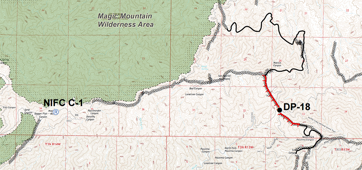
The Sand Fire is 93 percent contained and 41,432 acres. Fire managers now consider the contained dozer line that runs north and south from the North Fork Saddle Station part of the eastern perimeter.
The unburned vegetation west of the contained line along the Santa Clara Divide Road is now within the perimeter, increasing the acreage total.
[DOWNLOAD FULL MAP]
Resources include 1,038 total personnel, 42 engines, 24 hand crews, 6 helicopters, 10 water tenders, and 7 dozers. The US Forest Service and Los Angeles County Fire are in unified command.
Heavier gusts of wind in the Santa Clarita Valley are moving smoke around and visibility may decrease. Air quality in some areas may be at “unhealthy to sensitive groups” or “unhealthy” levels. Updates about smoke can be found on the California Smoke Blog or your local air district’s webpage: South Coast AQMD, Antelope Valley AQMD, Mojave Desert AQMD. For more information about how wildfire smoke can affect your health, visit AirNow.
Evacuation Centers: The American Red Cross announced Friday that it closed the Highland High School evacuation shelter because residents are returning to their homes or seeking other lodging needs. The shelter at Hart High School remains open (24825 N. Newhall Ave., Santa Clarita).
Closures: Two road closures are in effect: one at Sand Canyon Road and Placerita Canyon Road going into Bear Divide and one at Little Tujunga Canyon Road north of the Wildlife Way Station. An area, road, and trail closure is in effect on the Angeles National Forest(Forest Closure Order 01-16-05).
Firefighters on the Sand Fire working in the Magic Mountain Wilderness Area have been using minimum impact suppression tactics (MIST). Such tactics are used to suppress fires with the least environmental, cultural, and social impacts. It is a light-on-the-land, minimum-tool approach to accomplishing suppression, mop up, and repair operations. MIST are never used at the expense of firefighter safety. Examples of such tactics include constructing fireline only to the width and depth necessary for halting fire spread; cutting only snags that are a safety hazard; allowing the fire to burn to natural barriers; using high-pressure sprayers on equipment to help prevent the spread of invasive plants. MIST guidelnes are not intended to represent a separate or distinct class of firefighting tactics but rather a mindset: how to suppress a wildfire while minimizing the long-term effects of the suppression action.
Basic Information
| Current as of |
7/31/2016, 6:29:52 AM |
| Incident Type |
Wildfire |
| Cause |
Under Investigation |
| Date of Origin |
Friday July 22nd, 2016 approx. 02:15 PM |
| Location |
Northbound Hwy 14/Sand Canyon |
| Incident Commander |
Unified Command: SoCal Team 3, Mike Wakoski And LACoFD, Vince Pena |
| Incident Description |
Wildfire |
Current Situation
| Total Personnel |
1,038 |
| Size |
41,432 Acres |
| Percent of Perimeter Contained |
93% |
| Fuels Involved |
Chaparral, brush, and tall grass |
| Significant Events |
Fire activity is minimal with only scattered interior pockets of vegetation burning. |
Outlook
| Planned Actions |
Patrol, mop up, and suppression repair. |
| Projected Incident Activity |
Fire managers do not anticipate that the fire will spread. Crews will mop up and reinforce existing containment lines and repair lines affected by fire-suppression activities. |
Current Weather
| Weather Concerns |
Relative humidity recovery was 35-55 percent last night. Today will be slightly cooler with slightly higher relative humidity as some monsoonal moisture comes to the area. Thunderstorm threats in and near the fire are low (5-10 percent). |
Like this:
Like Loading...
Related


 Tweet This
 Facebook
 Digg This
 Bookmark
 Stumble
 RSS
RSS


REAL NAMES ONLY: All posters must use their real individual or business name. This applies equally to Twitter account holders who use a nickname.
5 Comments
I get the purpose of letting it burn but our air quality is horrible.
? what’s the purpose of letting a human-caused fire burn?
I agree with the above question.The air quality is so bad already and there is no place for the animals to go. Not to mention the flooding afterwards. And if the wind picks up and changes, they really can’t tell where it will go. You’ve really got to wonder about the forest service sometimes.
Perhaps a new philosophy or revisions in scientific opinion on the past policy of immediate and massive efforts to suppress fires is the reason.
Reports in the news indicated that most of the “Sand” fire area up in the high country hadn’t burned in many years (except where it met the “Station” fire burn area). There could also be concern that firefighting in the very vertical landscape is too dangerous versus letting it burn out on it’s own.
But my bet is they’ve cut back to minimum effort due to the cost, and since we don’t see the fire or feel threatened by it we won’t notice. They can always say the smoke has blown all the way down from Monterey or Fresno like they did last week.
Some have argued that the next year’s ANF firefighting budget depends (in part) on how many acres burned the prior year.