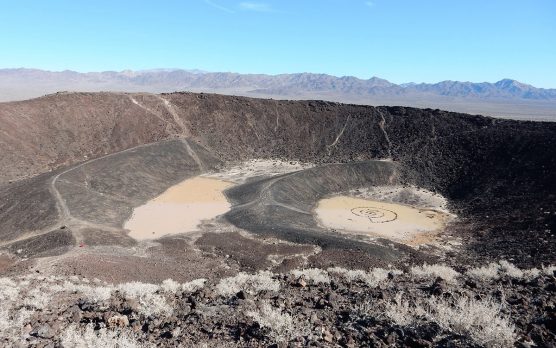
 If you find yourself traveling east on Interstate 40 to Needles or beyond, you might want to consider a short side trip to explore Amboy Crater National Natural Landmark. It’s located just off of National Trails Highway (Historic Route 66) about 28 miles east of the town of Ludlow.
Amboy Crater is an extinct cinder cone type of volcano that is about 79,000 years old. The most recent eruption was about 10,000 years ago. The inside of the 250-foot-high high crater contains two lava dams, behind which have formed small lava lakes. These are now flat in general appearance and covered with light-colored clay, creating the impression of miniature dry lakes. Beyond the crater lie 24 square miles of lava flow containing features such as lava lakes, collapsed lava tubes and sinks, spatter cones and massive flows of basalt. You will see some of those lava flows as you approach the crater on National Trails Highway.
Amboy Crater was designated a National Natural Landmark in 1973 due to its visual and geological significance. Although Amboy Crater is not unique, it is an excellent example of a symmetrical volcanic cinder cone. It is also in the Mojave Trails National Monument, which the president designated as a national monument earlier this year.
The scenic area around Amboy Crater was a popular sight and stop for travelers on Route 66 before Interstate 40 opened in 1973. Amboy Crater was only one of a few extinct volcanoes along the entire highway, so generations of Route 66 travelers from the 1920s through the 1960s would stop to visit the area. There was a significant decrease in visitors after Interstate 40 bypassed the crater, but there has been a recent resurgence due to increased interest in Historic Route 66 and the newly designated Mojave Trails National Monument.
If you want to get up close and personal with the crater, you can go on a short but scenic hike along the rim and into the crater. Due to the often extremely hot temperatures in the area, it is suggested you plan hikes roughly between the months of October thru April.
Be sure to bring your camera. The crater and the vistas from the rim of the crater can be spectacular. If the rainfall has been adequate, the spring months from March to May can bring displays of desert wildflowers such as desert primrose and sand verbena. You are also likely to see chuckwallas and zebra-tailed lizards in and around the rocks along the trail to the crater, especially in the mid-morning and early evening hours.
The trailhead is clearly marked and can be seen from the day-use parking lot. The trail itself is not well marked in places; if you lose the trail, keep heading toward the crater and you will likely come across a trail marker or find the trail again. The round-trip hike is about 3 miles.
Located about a mile from the day-use area, the cone is 1 mile in circumference.
Follow the trail to the west of the cinder cone. This will take you to an opening where an explosive eruption breached the crater wall. From here, you will need to scramble up the side to the rim of the crater – about an 80-foot incline. There is no sign marking this spot. Look for what appears to be a slight trail heading up the side of the crater.
ADA-accessible shaded and unshaded picnic tables and restrooms are available, as well as a shaded crater viewing platform about 250 feet from the parking lot.
There are a few important things to keep in mind when visiting the crater. First of all, during summer months or windy conditions, hiking to the rim is not recommended. There is an old scar on the face of the crater where many people hiked or tried to drive ATVs up the crater. This is not a trail and is dangerous. Please do not use it. Also, regular desert precautions should be taken: Stay alert for rattlesnakes and old military explosives, and be sure to bring a hat, sunscreen, sturdy shoes and plenty of water.
If you would like to visit Amboy Crater, there are two ways to get there from Santa Clarita. One way is by traveling to the city of Barstow. From Barstow, take Highway 40 to the Ludlow exit. Turn to the right on Bagdad Chase Road and then make a left on National Trails Highway (Route 66). Travel about 28 miles. Make a right when you see the sign for the Amboy Crater National Natural Landmark, and follow the road to the day-use parking lot.
The other way is by traveling to the city of Twentynine Palms. From Twentynine Palms, take Highway 62 to Utah Trail. Make a left on Utah Trail and then a right on Amboy Road. Continue on Amboy Road about 15 miles until it veers to the left (north). Continue on Amboy Road for another 27 miles until you reach the National Trails Highway (US-66) intersection in the town of Amboy. Make a left onto Route 66 and travel about three miles. Turn left when you see the sign for the Amboy Crater National Natural Landmark and follow the road to the day-use parking lot.
Linda Castro is a nature enthusiast and animal lover. She is the Desert Field Organizer for the California Wilderness Coalition and serves on the board of the SCV-based Community Hiking Club. Her commentaries relate to California’s deserts.


Like this:
Like Loading...
Related


 Tweet This
 Facebook
 Digg This
 Bookmark
 Stumble
 RSS
RSS


REAL NAMES ONLY: All posters must use their real individual or business name. This applies equally to Twitter account holders who use a nickname.
1 Comment
I love history and really love stories of the old Butterfield stage route and stops.LOVE it!!!!!