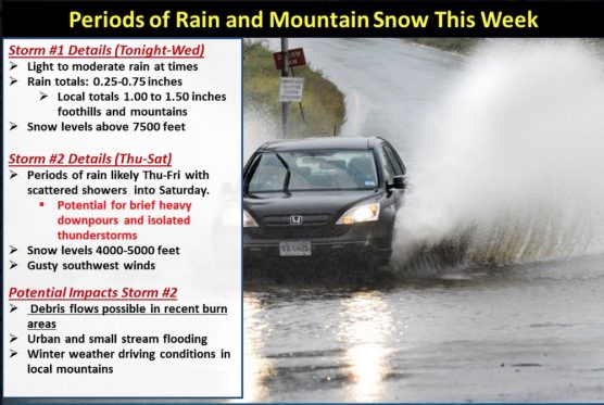
Southern California is on track for a wet week, according to the National Weather Service. Rain began to fall Monday night and is expected through Wednesday as a system moves through the area.
This storm is expected to produce light to moderate rainfall with totals generally ranging between 0.25 and 0.75 inches although some mountain and foothill areas could receive between 1.00 and 1.50 inches. Rainfall rates are expected to remain below USGS thresholds for the recent burn areas.
From Thursday through Saturday, a colder and more potent storm system will impact the area. At this time, confidence in the details of this second system are still on the low side. However, there is the potential for moderate to heavy rainfall, isolated thunderstorms and rainfall rates exceeding USGS thresholds for the recent burn areas. Additionally, the mountains could receive some snow accumulations as snow levels drop to 4000-5000 feet.
Like this:
Like Loading...
Related


 Tweet This
 Facebook
 Digg This
 Bookmark
 Stumble
 RSS
RSS


REAL NAMES ONLY: All posters must use their real individual or business name. This applies equally to Twitter account holders who use a nickname.
1 Comment
Edgar Rodriguez