 It was in the mid 1980s when I first visited Devil’s Punchbowl. At that time I was living at Edwards Air Force Base.
It was one of those weeks in which every day was the same and I needed a break from the monotony of the mind-blowing boredom I was experiencing. But where was I going to go? In my mind it seemed to take forever and a day just to get to the gate and then even longer to get to town. I really had to have a plan. Plus, I still wasn’t sure where I was going, since I was just recently stationed here. (Yes, a map would have been a smart idea, but who needs a map when you are on an adventure?)
Then a thought came to me. I remembered driving to March Air Force Base, where I had to take the 138 (Pearblossom Highway) to San Bernardino. I was simply fascinated by the Joshua trees standing proudly with arms outstretched as if to say “welcome.” And I seemed to remember a sign or two directing visitors to a park. So, this was the plan: Go back to Highway 138 and explore that area.
A week later I arrived. OK, so it seemed like a week to get there, when in reality it was probably a couple of hours. Not really knowing where I was going, I crossed south of the 138 and headed toward the mountains. My logic: You can never go wrong when you’re heading toward the mountains.
Each time I came to an intersection, I looked both ways and decided to go with my gut feeling. I took a series of lefts and rights as I worked my way up. And lo and behold, there was a sign for Big Rock Creek and Devil’s Punchbowl. I love the water; how could I pass up an opportunity to see something called a “punchbowl?”
I headed my car in the direction of the sign’s arrow. Although the road was empty of any other signs of human life, the landscape looked like a bountiful garden of exotic plants displaying their colors of yellow and rust and green and even purple. The road seemed to go up a slow grade, but my car was loudly disagreeing as the engine whined. After some time I thought I must have missed the park, distracted by the scenery. Finally, a wave of relief came over me as I saw a sign in the distance pointing left toward the park.
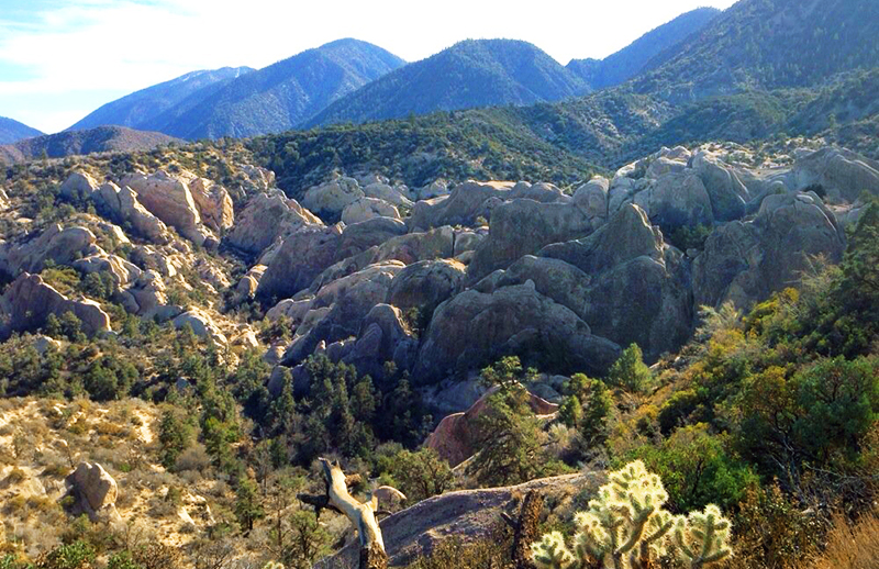
As I took the left and headed up the winding road, I saw in the distance rocks jetting out. It was amazing. They displayed like books sitting tilted on a shelf, all reddish in color. The surrounding area looked flat in comparison except for the mountains in the distance.
I couldn’t wait to get there. So many questions were filling my head. The biggest question was, “What caused this phenomenon?” I knew it had to be due to earthquakes, but this was something I have never seen back East, so I couldn’t be completely sure of this conclusion.
The road ended in the practically empty parking lot of Devil’s Punchbowl. I tore off my sandals and replaced them with my hiking boots and grabbed my waterpack. Alas, I didn’t have a proper backpack. The ranger station was closed, so my questions would be have to be answered by me trying to come up with my own conclusions.
I saw a lookout station and walked toward it. In front of me was the bowl. It was composed of varying hues of reddish sandstone. Some of the sandstone consisted of plate-like formations pushed up with one side facing the heavens and the other side deeply imbedded in the ground. Other sandstone formations had sinusoidal curves resembling the road just driven, while others had stratified layers.
I took the Loop Trail down into the bowl to take a closer look. The descent was about 300 feet, which is short compared to the 60 million years it took to form this bowl.
As I descended, I could only marvel at the visible layers of history set in the sandstone. Each layer is like a time capsule providing a glimpse of what happened at that time. (Unfortunately, during the last couple of years, certain areas of these time capsules are being covered over by senseless graffiti – an ignorant trend that is currently plaguing many parks.)
Layers that contain large rocks and gravel are usually indicative of large amounts of water racing down the side of a mountain taking everything in its path to the ground below. Fine sand layers indicate the rain was light, slowly carrying only the silt and fine sand. At the bottom was a slow-flowing stream, undoubtedly due to the snow melt from the mountains.
It was the forces of this stream that helped form the canyon I was in. It was also the stream that helped turn this once shallow ocean into the many layers of history by carrying the eroding mountainside down, eventually filling this ancient ocean floor.
As I followed the stream up, I saw smaller tributary streams that had carved out channels that were prime for exploring. I chose one such channel and followed the winding trail for a short time. I loved the different shapes of sedimentary rocks that nature’s forces had carved out. After a few minutes, I turned back. I needed to get going if I was to get to the Devil’s Chair and back before sunset.
I promised myself I would come back later to explore all of the nooks and crannies that the bowl had to offer. I quickly got back on the trail and ascended to the southern end of the Loop Trail. At the top I was greeted by many of the twisted smooth red bark and berry-laden shrub of the manzanita.
The trail split with the side following the rim of the canyon back to the ranger station. It was the other trail I wanted. It would eventually lead me to the Devil’s Chair trail – at least that is what I observed on the posted trail map by the ranger’s station. And, so it did. I was on my way.
The trail took a left and gradually down toward the first of several small streams. The desert chaparral dwindled as I started my first decent, which was probably due to the pine trees. I was amazed at how quickly the vegetation changed. The trail followed the contour of the mountain dropping down and then rising up over the next ridge.
I was never without a view. I could see the punchbowl below and farther out, the expansive desert floor. From my vantage point I could see all of the washes caused by the rains, the green alfalfa farms dotted around the valley floor and several dry lake beds. I could even make out Edwards AFB.
At one point, the trail made a turn and started to follow a ridgeline taking me away from the mountainside. I started to descend, noticing that the pine trees were quickly disappearing. Finally I came to a “T” in the path. The right trail would take me to South Fork and the left would take me to the Devil’s Chair. I took the left and followed the path as it hugged the dry slope of the mountain.
In places, the path seemed to disappear due to the erosion from the snow melt. The little vegetation that was on this slope was doing its best to slow down the erosion.
Again, the path took a turn. I was following what looked like the backbone of a dragon. On either side of the ridge was a quick drop down. The ridgeline ended in a small fenced outlook, presumably the chair. The view looked down into the punchbowl and then farther out where you could see uplifted rocks slanted in two different directions and then onto the valley floor. Behind me, rising 8,000 feet in elevation, were the snow-capped mountains. I was surrounded by the beauty and the solitude of nature. Life was good.
I have been visiting this park ever since my first visit. In fact, it is my first choice when taking my family and friends hiking due to the uniqueness and sheer beauty of the punchbowl. The punchbowl never ceases to amaze my guests or me. Each time I visit, I am greeted by something new.
What I also loved about this park is that it was run by essentially one man, David Numer. Later on his son, Johnathan, joined him as a ranger. They both clearly love this park and the surrounding areas. Both are knowledgeable and love to share their knowledge with you.
They maintain a small museum that contains live snakes, bugs, an active bee hive and learning boards depicting the geology and history of the area. They also have a couple of rescued owls living there. But that is only the start of what this small park offers. They offer for the entire family moonlit hikes down into the punchbowl while they talk about the history of the area and show you some of the geological wonders as you descend. I think what makes this so unique is that both children and adults feel the raw wilderness under the cover of the moon that our forefathers had felt.
On moonless nights, the park offers telescope programs. The last time I was there, I was amazed at the telescopes that the enthusiastic volunteers brought. They were so strong that I could clearly see the freckle on the nose of the man on the moon.
Both programs are offered only once a month. If you are interested in geology and the faults that created the punchbowl, they offer a program called San Andreas Fault Tour every Sunday at 1 p.m. This is such an interesting tour that Numer provides to everyone. You will learn there are actually three faults in this area causing the uplifting action; they are the Punchbowl Fault, the Pinyon Fault and the San Andreas Fault. Best of all, you can see all three faults and how each fault affected the landscape.
If you want to hike, then this is also the place to be. There are three different hikes that one can explore. The Punchbowl Loop trail, which descends into the punchbowl, is approximately 1 mile in distance. It is hot down there during the summer months, but during the rest of the year, it is pleasant. The Devil’s Chair trail is approximately 7.4 miles round trip. The trail has changed since my first visit. The park fenced in the backbone ridge toward the chair, presumably to protect people who lack common sense. I have seen an unfortunate increase of people creating shortcuts, knowingly or unknowingly destroying the fragile slopes and jeopardizing the plants and the stability of the area. The third hike is to Burkhart Saddle. This is a longer hike and more strenuous. It is 7.14 miles to the saddle and continues to Buckhorn Flat, located on Route 2. During the winter you can expect snow, and during the summer the hike is very hot but does offer areas of shade.
All of this information its location can be found at the Devil’s Punchbowl website, http://www.devils-punchbowl.com.
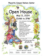
Gini Lomerson is a docent at the Placerita Canyon Nature Center.
Like this:
Like Loading...
Related


 Tweet This
 Facebook
 Digg This
 Bookmark
 Stumble
 RSS
RSS


REAL NAMES ONLY: All posters must use their real individual or business name. This applies equally to Twitter account holders who use a nickname.
4 Comments
In March while sitting in the “devil’s chair” we took great photos of 4 bighorn sheep. Too bad I cant attach them to share. This is really an awesome place! Thanks for sharing.
I miss hiking around and picnics there!
Hiking with my Grandma in 1971…I need to go back! Thanks for the reminder!
You missed your calling – you should be on the National Geographic Film and Photo crew.
Awesome article. Awesome lady. Please write some more. Please !!!!