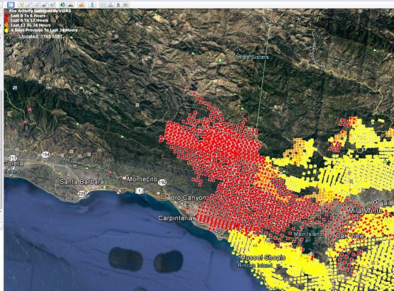
Update 8 p.m. Sunday: The Thomas Fire picked up speed and scope as wind speed picked up Sunday, and has now burned 230,000 acres, up from 173,000 early in the day, according to Ventura County Fire Department officials.
It’s now the fifth largest fire ever recorded in California.
Containment has been downgraded from 15 percent to 10 percent.
More than 100,000 people are under evacuation orders. More than 790 structures have been reported destroyed and another 190 damaged.
Original post, 2:53 p.m. Sunday: The Thomas Fire raged in Ventura County and west-northwest into Santa Barbara County Sunday afternoon, forcing evacuations as the blaze threatened the coastal communities of Carpinteria and Montecito and moved inland into the Los Padres National Forest.
Moderate Santa Ana winds pushed the fire Saturday night and will continue this afternoon, causing significant growth in the Carpinteria area, according to Sunday morning’s update from CalFire.
As of 7 a.m. Sunday, the fire continued to threaten various parts of the cities of Ventura, Ojai, Casitas Springs, Santa Paul, Carpinteria, Fillmore and the unincorporated areas of Ventura County and Matilija Canyon.
Fire officials expected the blaze to spread toward the Sespe Wilderness and the Sespe Condor Sanctuary. Firefighters continued to work aggressively to protect life and property while working on control efforts around the fire perimeter.
The Thomas Fire has destroyed 754 structures, damaged another 162 structures and charred 173,000 acres. It is only 15 percent contained. The best news: no civilian or firefighter deaths or injuries.
Nearly 4,500 firefighters, 611 engines, 31 water tenders, 30 helicopters, 51 bulldozers, 55 hand crews and other resources from Ventura, Santa Barbara and Los Angeles counties as well as nine neighboring states are battling the Thomas Fire, which broke out near Santa Paula Monday night, December 4.
As of 1 p.m. Sunday, Ventura County authorities reported evacuations have been lifted for some areas of the Ojai Valley, the cities of Santa Paula and Ventura, unincorporated areas between Ventura and Santa Paula, and unincorporated areas east and north of the Santa Paula City limits,
Mandatory evacuations are in effect for the Ventura County North Coast area from Highway 33 on the north to Casitas Vista Road; northwest to Highway 150; Highway 150 (Casitas Pass Road) west to US 101; and south on US 101 (including Pacific Coast Highway) to Emma Wood State Beach.
Mandatory evacuations remained in effect for parts of the city of Ventura, the entire community of Casitas Springs (where Johnny Cash lived in the ’60s), areas of Lake Casitas, Ojai Valley, and the city of Ojai.
Closest to the Santa Clarita Valley, on the eastern tail of the fire in the unincorporated area of Ventura County near Fillmore, evacuations are still in effect for the area of Hall Road to the west; Sespe Creek to the east; the Fillmore city limits to the south, and Los Padres National Forest boundary to the north.
See the complete list of Ventura County evacuations [here].
In Santa Barbara, as of 12:30 p.m. Sunday, the county Office of Emergency Management ordered evacuations expanded to include the areas from Hot Springs to the county line, and on the north (or mountain side) of Highway 192. Surrounding areas south (ocean side) of the 192 are under evacuation warning only.
See the complete list of Santa Barbara County evacuations and road closures [here].
Like this:
Like Loading...
Related


 Tweet This
 Facebook
 Digg This
 Bookmark
 Stumble
 RSS
RSS


REAL NAMES ONLY: All posters must use their real individual or business name. This applies equally to Twitter account holders who use a nickname.
5 Comments
Maggie Tauber Van Brunt
Can’t believe this…
Is fire retardant being dropped on this fire? If not, why not? If it has, where and how much? What is Ventura County’s policy on when to use retardant?
Nelly Barrera…Como esta tu Hna Cuca?
Creo q esta bien chela ,gracias