The Los Angeles County Operational Area Emergency Operations Center (CEOC) was activated at 6 a.m. in response to a strong winter storm moving through Los Angeles County. The storm system is impacting Los Angeles County cities and unincorporated area communities.
The storm system is forecasted to bring heavy rain, snow in the high elevations, isolated thunderstorms, and gusty winds to the area through Saturday. The CEOC is activated in support of the cities of Glendora, Azusa, Monrovia, Rancho Palos Verdes, Long Beach, and Los Angeles activations of their Emergency Operations Centers due to potential mud and debris flows.

Wet, but no snow as of 4:22 p.m. on the Alpaca Cam at the Lone Juniper Ranch outside of Gorman.
Snow accumulations between 6,000 and 8,000 feet will range from 6 to 12 inches with local amounts up to 18 inches. Accumulations will range from 1 to 4 feet of snow above 8,000 feet.
Periods of heavy snow and gusty winds will make travel hazardous across area roadways. The strongest winds will impact the higher peaks and ridges. Tonight’s winds are expected to range from 30 to 45 mph with gusts up to 70 mph.
ROAD CLOSURES
* City of Azusa – Sierra Madre for East and West traffic closed at Veterans Way due to flooding and traffic concerns.
* City of Azusa – Old San Gabriel Canyon Road, Azusa City Boundary to Angeles National Forest.
* City of Castaic – Lake Hughes Road
* City of Glendora (Angeles National Forest) – Glendora Mountain Road, Big Dalton Road to East Fork Road
* City of Glendora – Rainbow St. due to possible mudslide
* City of Malibu – Pacific Coast Highway closed between Yorba Buena to Deer Creek.
* Bouquet Canyon Road from Big Oaks Lodge to Mile Marker.
* Angeles National Forest: Glendora Ridge Road, Mount Baldy Road to Glendora Mountain Road
* Lake Hughes Road – 5.0 Miles South of Elizabeth Lake Rd / Elizabeth Lake Rd due to storm activities
* Avenue M – Quartz Hill Rd / 47th Street West due to water main break belonging to Palm Ranch Irrigation District
* Caltrans has closed PCH at Ventura County/LA County Border; increased traffic on Kanan Dume Road, Mulholland Highway, Decker Canyon Road and Encinal Canyon Road. Crews keeping full crews for rock blading in this area.

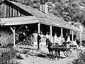
Lake Hughes Road in the Powerhouse Fire burn area | Photo by Teddy Hage
* Caltrans has closed PCH at Ventura County / LA County Border; increased traffic on Kanan Dume Road, Mulholland Highway, Decker Canyon Road and Encinal Canyon Road. Caltrans keeping full crews for rock blading in this area.
* Elizabeth Lake Road from Lake Hughes Rd to Munz Ranch Rd Road
* Little Tujunga Canyon Road from M.M. 8.51 to Placerita Canyon Road
* Upper Big Tujunga Canyon Road from Angeles Crest Hwy to Angeles Forest Hwy Road.
* Lake Hughes Road from Dry Gulch Road to Elizabeth Lake Road.
* Angeles Forest Hwy from Angeles Crest Hwy to Aliso Canyon Road.
* Mt Wilson Red Box Road from Video Road to Angeles Crest Hwy.
* Big Tujunga Canyon Road from Angeles Forest Hwy to LA City Boundary.
* Avenue M from Quartz Hill Road to 47th Street West.
* Bouquet Canyon Road from 1.9 Miles North Of Vasquez Canyon Road to 0.6 Miles South of Big Oaks Lodge.
* Old San Gabriel Canyon Road from Azusa City Boundary to Angeles National Forest.
* E. 90th St from Juniper St to S. Alameda St.
* Frontier Circus St from Ave P-8 to Stagecoach Ave.
* 134th Street West from Lancaster Road to Avenue G-12.
* 30th Street West from Avenue D to Avenue A.
* Avenue C from 30th Street West to Sierra Highway.
(Source: DPW Website http://dpw.lacounty.gov/roadclosures/):
ROAD (OPEN)
* Pacific Coast Highway between Yorba Buena Road and Los Posas Road. (Caltrans)
Los Angeles County residents and businesses, including persons with disabilities and others with access and functional needs, may call 211 LA County for emergency preparedness information, and other referral services. The toll-free 2-1-1 number is available 24 hours a day and seven days a week. 211 LA County services can also be accessed at http://211la.org. To register for the Specific Needs Awareness Planning program please go to https://snap.lacounty.gov. For additional disaster/emergency preparedness information, please access http://lacoa.org and/or http://espfocus.org.
Like this:
Like Loading...
Related


 Tweet This
 Facebook
 Digg This
 Bookmark
 Stumble
 RSS
RSS


REAL NAMES ONLY: All posters must use their real individual or business name. This applies equally to Twitter account holders who use a nickname.
6 Comments
What happened to the people?
How far down LH Rd from Lake Elizabeth Rd is this?
About half a mile
About half a mile
“I can make it honey, watch this.”
“I can make it honey, watch this.”