[NASA/JPL] – As Californians continue pumping groundwater in response to the historic drought, the California Department of Water Resources released a new NASA report Thursday showing land in the San Joaquin Valley is sinking faster than ever before – nearly 2 inches per month in some locations.
The report, Progress Report: Subsidence in the Central Valley, California, prepared for DWR by researchers at NASA’s Jet Propulsion Laboratory, Pasadena, California, is available at:
[NASA REPORT]
“Because of increased pumping, groundwater levels are reaching record lows – up to 100 feet (30 meters) lower than previous records,” said Department of Water Resources Director Mark Cowin. “As extensive groundwater pumping continues, the land is sinking more rapidly and this puts nearby infrastructure at greater risk of costly damage.”
Sinking land, known as subsidence, has occurred for decades in California because of excessive groundwater pumping during drought conditions, but the new NASA data show the sinking is happening faster, putting infrastructure on the surface at growing risk of damage.
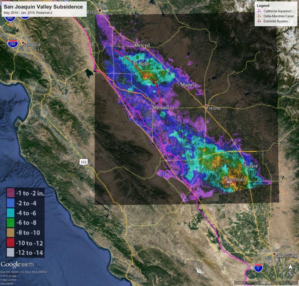
NASA obtained the subsidence data by comparing satellite images of Earth’s surface over time. Over the last few years, interferometric synthetic aperture radar (InSAR) observations from satellite and aircraft platforms have been used to produce maps of subsidence with approximately centimeter-level accuracy. For this study, JPL researchers analyzed satellite data from Japan’s PALSAR (2006 to 2010); and Canada’s Radarsat-2 (May 2014 to January 2015), and then produced subsidence maps for those periods. High-resolution InSAR data were also acquired along the California Aqueduct by NASA’s Uninhabited Aerial Vehicle Synthetic Aperture Radar (UAVSAR) (2013 to 2015) to identify and quantify new, highly localized areas of accelerated subsidence along the aqueduct that occurred in 2014. The California Aqueduct is a system of canals, pipelines and tunnels that carries water collected from the Sierra Nevada Mountains and Northern and Central California valleys to Southern California.
Using multiple scenes acquired by these systems, the JPL researchers were able to produce time histories of subsidence at selected locations, as well as profiles showing how subsidence varies over space and time.
“This study represents an unprecedented use of multiple satellites and aircraft to map subsidence in California and address a practical problem we’re all facing,” said JPL research scientist and report co-author Tom Farr. “We’re pleased to supply the California DWR with information they can use to better manage California’s groundwater. It’s like the old saying: ‘you can’t manage what you don’t measure’.”
Land near Corcoran in the Tulare basin sank 13 inches (33 centimeters) in just eight months — about 1.6 inches (4 centimeters) per month. One area in the Sacramento Valley was sinking approximately half-an-inch (1.3 centimeters) per month, faster than previous measurements.
Using the UAVSAR data, NASA also found areas near the California Aqueduct sank up to 12.5 inches (32 centimeters), with 8 inches (20 centimeters) of that occurring in just four months of 2014.
“Subsidence is directly impacting the California Aqueduct, and this NASA technology is ideal for identifying which areas are subsiding the most in order to focus monitoring and repair efforts,” said JPL research scientist and study co-author Cathleen Jones. “Knowledge is power, and in this case knowledge can save water and help the state better maintain this critical element of the state’s water delivery system.” UAVSAR flies on a C-20A research aircraft based at NASA’s Armstrong Flight Research Center facility in Palmdale, California.
The increased subsidence rates have the potential to damage local, state and federal infrastructure, including aqueducts, bridges, roads and flood control structures. Long-term subsidence has already destroyed thousands of public and private groundwater well casings in the San Joaquin Valley. Over time, subsidence can permanently reduce the underground aquifer’s water storage capacity.
“Groundwater acts as a savings account to provide supplies during drought, but the NASA report shows the consequences of excessive withdrawals as we head into the fifth year of historic drought,” Director Cowin said. “We will work together with counties, local water districts, and affected communities to identify ways to slow the rate of subsidence and protect vital infrastructure such as canals, pumping stations, bridges and wells.”
NASA will also continue its subsidence monitoring, using data from the European Space Agency’s recently launched Sentinel-1 mission to cover a broader area and identify more vulnerable locations.
DWR also completed a recent land survey along the Aqueduct — which found 70-plus miles (113-plus kilometers) in Fresno, Kings and Kern counties sank more than 1.25 feet (0.4 meters) in two years — and will now conduct a system-wide evaluation of subsidence along the California Aqueduct and the condition of State Water Project facilities. The evaluation will help the department develop a capital improvement program to repair damage from subsidence. Past evaluations found that segments of the Aqueduct from Los Banos to Lost Hills sank more than 5 feet (1.5 meters) since construction.
NASA and the Indian Space Research Organisation are jointly developing the NASA-ISRO Synthetic Aperture Radar (NISAR) mission. Targeted to launch in 2020, NISAR will make global measurements of the causes and consequences of land surface changes. Potential areas of research include ecosystem disturbances, ice sheet collapse and natural hazards. The NISAR mission is optimized to measure subtle changes of Earth’s surface associated with motions of the crust and ice surfaces. NISAR will improve our understanding of key impacts of climate change and advance our knowledge of natural hazards.
Like this:
Like Loading...
Related


 Tweet This
 Facebook
 Digg This
 Bookmark
 Stumble
 RSS
RSS


REAL NAMES ONLY: All posters must use their real individual or business name. This applies equally to Twitter account holders who use a nickname.
14 Comments
And LA County has approved how many new housing projects? The one off the 126 will also include a road through Stevenson Ranch to the 126 allowing the dump trucks to go through their neighborhoods. Now is that what we want in Santa Clarita? Do we really want to take water from Central California, ruining their lives for some more housing here? I hope not!
Are you sure? Or are you lying like most people on Facebook?
True! Went to a class tonight and a meteorologist talked about this exact thing.
If most people lie on Facebook, why would you even ask? Do your own research.
An easy Google Search brings up more than one news article.
I’m sure digging would reveal the research paper somewhere.
liar!!!!! There is too much water and you are all going to drown in much dessication and sunshine……..
Makes sense, you take water out of the ground it leaves space dirt fills the space…
Cindy Schneider…..not lying. look up Citizens for Chiquita Canyon Landfill Compliance on Facebook or their web site http://www.c4cclc.com/
There you will find all the documentation about the landfill expansion.
By next month Fresno will be gone.
So potentially we could be sitting on the largest sink hole ever?Ruh roh raggy
Armpit of California truly becoming an armpit
One sprinkle on the cupcake of reasons I just moved out of Cali! Dont miss it at all
California’s slowly circling the drain….literally.
Nice catch Geeerd! be wary peeps