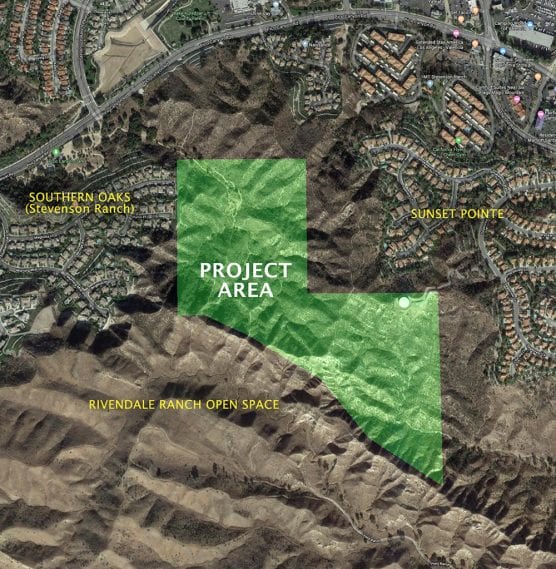
Developers of a proposed 37-home project on 94.3 vacant acres west of Interstate 5 near Pico Canyon in the southwest Santa Clarita Valley may finally get the green light to build when the Los Angeles County Planning Commission meets Wednesday.
With public hearings and environmental impact reports required by the California Environmental Quality Act, or CEQA, completed, the county Department of Regional Planning staff has recommended the Commission grant final approval to applicant Pico Canyon, LLC, subject to a few conditions, according to the county project documents.
Recommendations also include Commission approval of a “mitigated negative declaration,” which among other things would allow grading of the land but also require developers to watch out for and protect any paleontological or cultural artifacts that may be unearthed in the process.

Project Location, Description
The Pico Canyon, LLC development would be built on vacant property in unincorporated LA County west of Interstate 5, north of State Route 118 and south of State Route 126, between Stevenson Ranch and open space owned by the city of Santa Clarita.
The property is southwest of Pico Canyon Road, adjoining the existing Magnolia Lane cul-de-sac. Pico Canyon Park is northwest of the site, and the Rivendale Ranch Open Space is adjacent along the site’s south side.
Owned by Thousand Oaks-based Jemstreet Properties, Pico Canyon, LLC applied for a permit to create 37 single-family lots, two open space lots, five basin lots and one retention-water quality basin lot on 94.38 acres.
The application also requested a Conditional Use Permit allowing grading on a hillside in a county-designated “heavy agricultural zone” with slopes greater than 25%, and an Oak Tree Permit to remove one of the five oak trees now on the property, to be replaced by two trees to be planted elsewhere on the site.
The proposed development is in a county-designated “very high fire hazard severity zone,” while the southwestern portion of the property lies within the Santa Susana Mountains/Simi Hills “significant ecological area.”
To meet approval, Pico Canyon, LLC designed the project as a density-controlled development that clusters the home lots less than two acres in size to minimize grading, keep development out of the ecologically sensitive area, and preserve nearly 60 acres as contiguous natural open space.
Pico Canyon, LLC intends to dedicate the open space to the city of Santa Clarita, which has expressed interest in accepting 60-65 acres from the project as long as certain stipulations are met, according to project documents.
The project must also follow 2020 Building Code which now requires solar systems for all new low-rise residential development. Additionally, future residences will include energy-efficient HVAC units, windows, light fixtures, low-flow plumbing fixtures and irrigation systems, and drought-tolerant landscaping where feasible.

Magnolia Lane Extension
Access to the new development would be provided by extending Magnolia Lane, a 64-foot wide public road that would be extended eastward to provide primary access to and from the existing Southern Oaks subdivision.
Two public streets each measuring 60 feet wide (enough for parking on both sides of the street), designated as “A” and “B” Streets, would branch off of the Magnolia Lane extension to the east and terminate in cul-de-sacs. A third 58-foot-wide public street (“C” Street) would branch off of “B” Street to the north.
All streets would be improved with a 5-foot-wide sidewalk separated by a 7-foot-wide landscaping buffer to increase pedestrian safety and provide a visually pleasing streetscape. One street tree would be planted for every 25 feet of lot frontage, for a total of 151 new tree plantings.
Magnolia Lane currently provides access to Pico Canyon Road, designated a “major highway” by the county General Plan’s Highway Plan Policy Map, for 36 dwelling units in adjacent developments. Pico Canyon, LLC’s proposed 37 dwelling units would bring the total to 73 dwelling units using the extended Magnolia Lane as the primary access.
Lot Sizes, Dirty Details
Residential lots in the new development would range from 8,692 square feet to 27,971 square feet, with the median lot size at 11,182 net square feet. The clustered development would occupy 24.02 acres compared to 74 acres for 37 two-acre lots, which doesn’t account for the land needed to accommodate the necessary road network and public facility lots.
The proposed lot size is similar to residential lots along Magnolia Lane within the Southern Oaks subdivision.
Approximately 79% of the Pico Canyon, LLC site, or 74.33 acres, would be provided as open space with the majority, 63.4%, retained in a natural state. Improved open space would total 12.45 acres and include fuel modification areas (2.56 acres) and water quality and debris basins (9.89 acres).
A total of 823,000 cubic yards of grading is proposed which includes 375,000 cubic yards of cut, 375,000 cubic yards of fill, and 73,000 cubic yards of over-excavation.

Required Mitigation Measures
The environmental analysis found potentially significant impacts associated with the development that can be reduced to less than significant by implementing proposed mitigation measures.
• Biological Resources: The project would impact slender mariposa lilies, coast horned lizard, silvery legless lizard, coastal whiptail, San Diego black-tailed jackrabbit and San Diego desert woodrat. Impacts to these plants and animals would be mitigated to less than significant by implementing 11 biological mitigation measures.
• Cultural Resources: If archaeological cultural resources are inadvertently encountered during ground-disturbing activities, work shall be halted or diverted away from the vicinity of find so that the find can be evaluated by a qualified archaeologist.
Additionally, the developer would employ a qualified paleontologist to develop and implement a monitoring program for construction excavations that might encounter older Quaternary alluvium or deposits associated with Pico Formation, Saugus Formation, or Towsley Formation.
If a fossil is discovered, the paleontological monitor would be allowed to temporarily divert or redirect grading and excavation activities in the area of the exposed fossil to facilitate evaluation and salvage.
• Tribal Cultural Resources: A tribal cultural monitor shall be present during all activities related to grading to ensure impact to any tribal cultural resources is less than significant.
The Fernandeno-Tataviam Band of Mission Indians, whose ancestors first populated the area, was contacted in 2017, and arrangements have been made for a Native American tribal cultural monitor to be on the property during grading, according to project documents.
• Noise: To reduce noise impacts, only grading and construction equipment with the least output available would be allowed to operate on lots nearest the Southern Oaks community, and grading and construction equipment used on these lots shall have enhanced mufflers for noise reduction. Additionally, grading and construction on lots nearest the Southern Oaks community shall only occur from 8 a.m. to 5 p.m. Monday through Friday, except for legal holidays.
• Public Services: During construction, on-going communication shall be maintained with the school administration at the Pico Canyon Elementary School, providing sufficient notice to forewarn students and parents/guardians when existing pedestrian and vehicle routes to the school may be impacted to minimize impacts to school-related traffic and ensure pedestrian safety.
Additionally, construction vehicles will be prohibited from passing the Pico Canyon Elementary School except when school is not in session and crossing guards shall be provided when the safety of students may be compromised by construction-related activities at impacted school crossings.

The project has a rural land use designation and is therefore subject to the county’s Rural Outdoor Lighting Ordinance, intended to limit light intrusion and promote dark skies. Public street lighting would be installed where necessary, as determined by the Department of Public works. Public street lights are required to be designed to deflect light away from adjacent parcels and prevent off-street illumination and glare.
The Commission found that the project is consistent with the Santa Clarita Valley General Plan by recognizing the historic significance of Mentryville in Pico Canyon (pictured above) in future planning, preserves the existing rural development pattern, and ensures compatibility with the adjacent Significant Ecological Area and habitat.
To date, Pico Canyon, LLC has received necessary approvals from the Subdivision Committee (Departments of Public Works, Fire, Parks & Recreation, and Public Health); the Forestry Division of the LA County Fire Department; the county Sanitation Districts; California Department of Fish and Wildlife; and the West Ranch Town Council.
After developers presented the project before the Southern Oak Homeowners Association at a meeting on April 23, 2018, the HOA expressed concerns about increased traffic along Magnolia Lane, air quality issues resulting from project construction, construction noise, and incompatible home size, according to project documents.
A proposal dated July 19, 2018, was submitted to the HOA listed a variety of project changes, including off-site traffic calming measures, fund a security system for the HOA, limit construction hours, restrict construction parking along Magnolia Lane, provide a street sweeper on Magnolia Lane once a week until the Magnolia Lane extension is paved, and limit the floor area of future residences to 3,500 square feet, to address concerns raised at the
April meeting.
According to the subdivider, the HOA discussed and rejected the proposal. However, the latter four suggestions have been incorporated into the CUP
conditions, according to project documents.
Planning officials received one phone call in late January from a neighbor who expressed opposition to the project due to fire and traffic concerns. The caller said he would submit a letter prior to Wednesday’s hearing.
To read the entire 244-page Pico Canyon, LLC hearing package, click here.

Mentryville used to have a few more buildings than it has today.
— This story has been updated with corrections about the Southern Oak Homeowners Association’s response to the proposed development.
Like this:
Like Loading...
Related


 Tweet This
 Facebook
 Digg This
 Bookmark
 Stumble
 RSS
RSS


REAL NAMES ONLY: All posters must use their real individual or business name. This applies equally to Twitter account holders who use a nickname.
5 Comments
Time to leave California. Too much traffic etc. next will be murder, accidents, robberies, more shootings.
rather a strange article. Looks like an ad for the developer. All the positives and none of the negatives, like continuing to build in a very high fire hazard area with only one exit, exactly what the county’s own reports have advised against. Also, maybe the writer should go out and look at the project and see why it hasn’t been built in the last 30 years that it is on the books. They will have to move all the construction equipment through an existing neighborhood, They are cutting off a mountain and filling a canyon, over 900,000 cubic yards of dirt moved for 37 houses, only one evacuation exit with the number of houses exceeding the limit for fire safety. 27 opposition letters, 10 people ahowed up at the hearing to oppose. At least some of these issues should have been in the article.
The purpose of an article like that is to inform the public of something they didn’t know is going on. It doesn’t take sides, it tells people what’s coming. We rely on you, Lynne, to fight it :)
I am the developer of this project and I wonder who stated that we received approval from the Southern Oaks HOA? That is an incorrect statement and I would appreciate a retraction in fairness to the community and us. Thank you,
Jon Friedman
So Unfortunate! The reason why I moved to the area from L.A is to live surrounded by nature and now of course, they want to build more houses, there will be more traffic, less spots for kids in schools close by. This project is a horrible HORRIBLE IDEA.