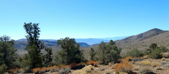
 Conglomerate Mesa lies in the southern Inyo Mountains, sandwiched between the Sierra Nevada range and Death Valley National Park. The nearest towns are Olancha to the southwest and Lone Pine to the northwest.
The mesa itself is an impressive landform when seen from a distance, extending from 3,800 to 7,100 feet in elevation. Visitors who clamber to the top via the historic, unmarked Keeler-Death Valley footpath are treated to expansive views of multiple wilderness areas, Owens Lake, and the glittering Sierra Nevada. On clear days, Telescope Peak in Death Valley is visible.
Unfortunately, Conglomerate Mesa is being threatened with a gold mine. Historically, mining has taken place in and around Conglomerate Mesa since the 1800s. The area holds a unique collection of historic-era mining features, particularly associated with early charcoal production for Cerro Gordo and smelters in the Owens Valley. However, mining in the Conglomerate Mesa area appears to have been done by small groups of “amateurs” and had little to no impact on the area. Larger operations took place at nearby Cerro Gordo.
The approach to Conglomerate Mesa is nearly as stunning as the view from the top. The Saline Valley road winds north from Highway 190 through Centennial Flats, which hosts a dense Joshua tree forest. It is unusual to see another car along the rough dirt road, but Mohave ground squirrels and other small mammals often scurry across.
Since Conglomerate Mesa is situated in a transition zone along the eastern edge of the Mojave Desert and the western edge of the Great Basin, the area has high plant diversity. In the lower elevations, one can find Joshua trees and cholla cactus. At higher elevations, the vegetation changes to pinyon-juniper woodlands.
The area was a traditional pinyon nut gathering location for indigenous peoples, evidenced by lithic materials and ceramic fragments dating to the contact period in the Owens Valley and earlier. It remains an important modern day tribal site.

Other unique and sensitive flowering plants, such as Ripley’s cymopterus and the Inyo rock daisy have been found in the area, as well. More common plants found in the area include Cooper’s goldenbush, matchweed, Great Basin sagebrush, black sagebrush, spiny hop-sage, and several varieties of buckwheat and cacti.
Golden eagles, prairie falcons, hawks and owls frequent the skies above Conglomerate Mesa, hunting for the lizards, snakes and other small wildlife that make the mesa home. At night, Townsend’s western big-eared bats seek out moths and other insects.
Badgers, bobcats, foxes, and coyotes can be found on the ground. The upland areas of the mesa provide important winter mule deer habitat and overwintering sites. Conglomerate Mesa is also a key part of larger movement corridor for Nelson’s bighorn sheep. In turn, the presence of mule deer and bighorn sheep supports mountain lions.
The Canadian mining company SSR Inc. proposes to drill seven exploratory drill sites to attempt to locate gold deposits in the heart of the mesa. To accomplish these exploratory drilling areas, the company would either have to construct roads in this otherwise roadless area or fly in the equipment with helicopters. It is hard to imagine either thing happening in this peaceful and unmarred landscape.

If the mining company does locate gold during the exploratory drilling phase, the next step would be a proposal for an industrial-scale open-pit mine, also known as a cyanide heap-leach mine. It is well documented that cyanide heap leaching poses significant hazards to plants and animals and contaminates scarce water resources. This mining operation would damage the area’s wild character, wildlife and habitat.
The Bureau of Land Management, which manages the Conglomerate Mesa area, has designated this area an “Area of Critical Environmental Concern” in order to protect the cultural values and rare plant and animal species and habitat found in the area.
BLM has also identified Conglomerate Mesa as having wilderness characteristics. A recently completed BLM land use plan covering the vast majority of the California desert recognized the scenic and wild values of the area by designating it “California Desert National Conservation Land,” thus adding it to the National Landscape Conservation System.
BLM is in the process of conducting an environmental assessment for the exploratory mining activities and is soliciting public comment. To learn more about the mining proposal and to submit a public comment to BLM, please visit https://www.calwild.org/action-alert-conglomerate-mesa/.
Conglomerate Mesa is no place for an industrial open-pit mine.
Linda Castro is a nature enthusiast and animal lover. She is the Assistant Policy Director for the California Wilderness Coalition and serves on the board of the SCV-based Community Hiking Club. Her commentaries relate to California’s deserts.

Like this:
Like Loading...
Related


 Tweet This
 Facebook
 Digg This
 Bookmark
 Stumble
 RSS
RSS


REAL NAMES ONLY: All posters must use their real individual or business name. This applies equally to Twitter account holders who use a nickname.
3 Comments
Thanks for bringing this to our attention.
I’ve never been there, but it sounds lovely. So sad to hear that its destruction is being considered.
All of our public lands are under threat from Ryan Zinke. He has reduced grazing fees on public lands, mining maintenance fees on public lands are criminally low and he proposed more public land to be exploited to the oil and mining interest. He proposes raising visitor fees from $30 to $70 on 17 National Parks of which 15 are located in the West.
File a public comment