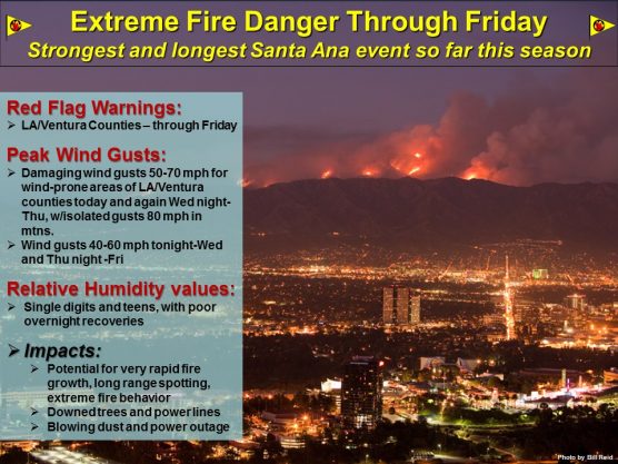
A strong surface high over California’s Great Basin will bring an extended period of moderate to strong Santa Ana winds to the Santa Clarita Valley, the San Fernando Valley and Ventura County coastal valleys through Friday, the National Weather Service reported Wednesday morning.
Winds are expected to weaken slightly today then increase again tonight and Thursday and continue through Friday.
During the stronger periods damaging wind gusts of 60 to 80 mph will be likely across the mountains, and damaging gusts up to 60 mph will be possible across wind prone portions of the valleys in western Los Angeles and eastern Ventura Counties.
The influx of cold and very dry air will allow temperatures overnight to drop below freezing again early Wednesday morning across wind-sheltered portions of San Luis Obispo and Santa Barbara Counties as well as the Ojai Valley.
* Winds and Timing: Areas of northeast winds 20 to 30 mph with gusts to 50 mph can be expected through this evening. Gusts to
60 mph are possible again tonight through Thursday.
* Impacts: Winds this strong may down trees and power lines, causing property damage or power outages. In addition, there
is the potential for blowing dust and debris, especially near recent burn areas. Crosswinds can make driving difficult,
especially for drivers of high profile vehicles and vehicles towing trailers.
Instructions
When driving, use extra caution. Be prepared for sudden gusty crosswinds.
A High Wind Watch means that conditions are favorable for potentially damaging winds of 58 mph or greater. Be prepared to secure all loose outdoor furniture in advance of the onset of strong winds. Monitor the latest forecasts on NOAA Weather Radio or your favorite media source.
Like this:
Like Loading...
Related


 Tweet This
 Facebook
 Digg This
 Bookmark
 Stumble
 RSS
RSS


REAL NAMES ONLY: All posters must use their real individual or business name. This applies equally to Twitter account holders who use a nickname.
0 Comments
You can be the first one to leave a comment.