header image

[Sign Up Now] to Receive Our FREE Daily SCVTV-SCVNews Digest by E-Mail

Inside
Weather


Calendar
Today in
S.C.V. History
March 30
1993 - Federal govt. declares coastal California gnatcatcher (bird) a threatened species [story]
Gnatcatcher


Commentary by Dianne Erskine-Hellrigel
| Sunday, Jul 2, 2017

The summit of Mt. Whitney is the highest point in the contiguous United States, reaching an elevation of 14,508 feet. (This is a bit higher than it was believed to have been; a recent survey just put it at that height.) And just across the mountains, 84.6 miles away in Death Valley, you will find Badwater Basin, the lowest point in the contiguous U.S.

Mt. Whitney attracts climbers from all over the world. For those of us in Los Angeles County, the trail head is a mere three hours away at most. To get there, head north on SR-14 to Mojave, where the highway takes a 90-degree right turn and eventually becomes Highway 395. Follow the 395 all the way to the cute little town of Lone Pine, and you’ll find the mountain looming off to the left with some magnificently jagged peaks. It makes a great photo or two, even if you have no intention of climbing it.

To get to the trail head, you’ll need to follow Whitney Portal Road. It’s only about 13 miles, but you’ll be doing some significant climbing. The elevation up there is 8,361 feet. That’s as far as you can go by vehicle. Now, you’ll need to make the decision to walk the rest of it or be satisfied with the lovely scenery at the portal.

The gorgeous canyon is part of the Inyo National Forest. There are three campgrounds nearby where you can stay and just enjoy the scenery of the Inyo. There is also a fabulous store where you can get any little thing you might have forgotten – and some pretty good grub, too.

Even if you’re not an avid climber like me, half of the fun is in meeting people from all over the world who are about to climb or who are just returning from the summit. You can enjoy some pretty awesome conversations from these great adventurers. More than 20,000 people climb this mountain every year, so you’re bound to run into some real characters.

If you’ve never hiked before, I suggest you start hiking some easier trails and build up your strength before you attempt Whitney. You start at 8,300 feet. Some people get acute mountain sickness at that altitude. And if you don’t know what you’re doing, you can get yourself into a lot of trouble.

It’s best to be prepared. Train. Know what you’re up against. Be ready for it. Rain, snow, sleet, hail, high winds, thunder and lightning can all add to your woe on the mountain. You might consider hiring a guide if you’ve never climbed a mountain before, just to be safe. There are plenty of outfitters waiting just for you.

A guide can tell you what to take and what not to take. If you start off with an 85-pound pack, you’re probably not going to get very far. On the other hand, you need to have everything with you in case of any type of emergency – plus food, plus water, plus, plus, plus, plus. Experience and a guide are your best friends. You’re going to have a gain of 6,208 feet, spread out over the 11 miles to the top. That’s pretty steep. And don’t forget, you’re doing some mighty tough, steep descending on the way down. Those knees are going to take a real beating.

So, maybe climbing Whitney is not for you. How about a visit to the lowest spot in the U.S.A.? Unlike Mt. Whitney, which can scare away the typical tourist, you will see plenty of domestic and foreign tourists at Badwater.

I suggest you do not go there in the summer. You’re in Death Valley, the lowest place in North America, and it can get hot – really hot. In fact, the hottest temperature ever recorded on Earth was right there. It was 134 degrees in 1913, and that record has yet to be broken.

When you’re there, take a look up on the hill behind the parking lot. There is a small sign way up there, telling you that you are 282 feet below sea level. Imagine that. Now, that’s worth a picture.

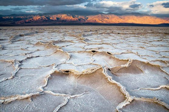
Badwater is about 200 square miles of hard salt pan. There’s a trail where hundreds of thousands of feet have crushed the salt crystals down. I suggest you stay on that trail so others can enjoy the beautiful salt crystals that form and grow several inches above the muddy base. If you sit or lie down on the flat portion of the trail, you can get some magnificent photos of the salt crystals.

There used to be a lake there called Lake Manly. There’s usually a little water here and there, and there’s always a little bit of water under the salt crystals. But sometimes, during exceptionally wet weather, Badwater will, for a brief time, again resemble a lake. Maybe you’ll be lucky enough to snap that photo.

Death Valley is a place of geologic wonders, and in the spring, the flowers can be amazing. So, don’t just stop at Badwater. See everything. You’ll be glad you did.


Dianne Erskine-Hellrigel is executive director of the Community Hiking Club and president of the Santa Clara River Watershed Conservancy. Contact Dianne through communityhikingclub.org or at zuliebear@aol.com.


Comment On This Story
COMMENT POLICY: We welcome comments from individuals and businesses. All comments are moderated. Comments are subject to rejection if they are vulgar, combative, or in poor taste.
REAL NAMES ONLY: All posters must use their real individual or business name. This applies equally to Twitter account holders who use a nickname.

1 Comment

  1. jim says:

    I suggest that anyone who has not climbed a 10,000 ft peak first may want to start elsewhere than Mt. Whitney. Just like anyone who has never been at Badwater in Death Valley should not go there without planning, assistance and maybe even some training,

    Unless of course, they are going by an elegant coach trip that provides plenty of staff and trained medical support. Death Valley Temps are going to be from 115 to 120F this next week, and most folks (including the Europeans) won’t be prepared for that. Although the foreign folks are expecting those extremes. That is a major part of the thrill for them.

    As for ascents of Mt. Whitney, the trail is very clear, and can be made by most healthy people. Unless of course they are subject to altitude sickness, in which case they will be somewhere in between Whitney Portal and the peak when it strikes. Few people die from this illness, but many of them need assistance returning to lower altitudes. A severe case may require medical attention and much more assistance returning to the base.

    It’s not a lark folks, unless you are young, healthy, and relatively immune to altitude sickness.

Leave a Comment


Opinion Section Policy
All opinions and ideas are welcome. Factually inaccurate, libelous, defamatory, profane or hateful statements are not. Your words must be your own. All commentary is subject to editing for legibility. There is no length limit, but the shorter, the better the odds of people reading it. "Local" SCV-related topics are preferred. Send commentary to: LETTERS (at) SCVNEWS.COM. Author's full name, community name, phone number and e-mail address are required. Phone numbers and e-mail addresses are not published except at author's request. Acknowledgment of submission does not guarantee publication.
Read More From...
RECENT COMMENTARY
Thursday, Mar 27, 2025
Our family has called Santa Clarita home since 1972 and I take great pride in our city’s beautiful paseos, scenic trails and vibrant neighborhoods.
Wednesday, Mar 26, 2025
Los Angeles County Board of Supervisors Chair Kathryn Barger strongly supports Public Works’ recent request to FEMA for the inclusion of debris removal from commercial, residential, and non-residential properties impacted by the Eaton, Hurst, Palisades, and Sunset Fires. Barger issued the following statement today:
Monday, Mar 24, 2025
Spring is fast approaching and the moment we’ve all been waiting for is right around the corner.
Thursday, Mar 20, 2025
Old Town Newhall is the place to go if you’re looking for arts, entertainment, dining, shopping and events.
Monday, Mar 17, 2025
Old Town Newhall has earned its title as Santa Clarita’s Premier Arts and Entertainment District and has also become well-known as a hub for prime dining and shopping.
Friday, Mar 14, 2025
After the January wildfires, the county began a review to assess our evacuation policies and emergency alert systems. The state has also commissioned a review of our preparedness efforts, immediate response to the fires and the recovery time frame of the incident.

Latest Additions to SCVNews.com
1993 - Federal govt. declares coastal California gnatcatcher (bird) a threatened species [story]
Gnatcatcher
The "Superman" roller coaster, closed for refurbishment since September, will now be closed permanently, said officials of Six Flags Magic Mountain.
‘Superman’ at Six Flags Magic Mountain Permanently Grounded
Los Angeles County Sheriff’s Department Missing Persons Unit is asking for the public’s help locating At-Risk Missing Juvenile Isabell Ann Lim. She is a 13 year-old female Asian who was last contacted on March 28 at 9:40 a.m. on the 17900 block of River Circle, in the city of Santa Clarita.
LASD Seeks Public’s Help Locating Missing Santa Clarita Teen
1928 - Little dam victim, thought unidentified & buried in SCV, actually ID'd & buried in Chatsworth [story]
Newhall Cowboys
The Sierra Hillbillies Square and Round Dance Club invites you to the National Tartan Day themed Square and Round Dance on Sunday, April 6, 2-4:30 p.m.
April 6: Sierra Hillbillies Host National Tartan Day Square, Round Dance
The city of Santa Clarita’s Community Emergency Response Team Program is looking for volunteers to act as injured survivors for the Disaster Simulation drill on Friday, May 9, from 6–9 p.m.
May 9:  City Seeks Volunteers for Disaster Simulation Drill
The South Coast Air Quality Management District issued an Order for Abatement on Thursday, March 20, requiring Sunshine Canyon Landfill to implement stricter and innovative measures to reduce odors that have been impacting the community.
Sunshine Canyon Landfill Required to Take Stronger Actions to Address Odors
The Saugus Union School District is seeking nominations for the annual Dr. Joan Lucid Leadership and Service Award.
SUSD Seeks Nominations for Lucid Leadership, Service Award
Registration is open for the city of Santa Clarita's Community Emergency Response Team training class.
City Offers Free Community Emergency Response Team Training Class
The city of Santa Clarita has announced the launch of the second annual Animal Care Grant Program.
City Invites Community Organizations to Apply for Animal Care Grants
In response to Governor Gavin Newsom’s recent executive order removing California Environmental Quality Act requirements for undergrounding utility lines in wildfire-impacted areas of Los Angeles County, California State Senator Suzette Valladares (R-Santa Clarita) has called for this exemption to be applied statewide.
Valladares Calls for Streamlining Process for Underground Power Lines
Among several important issues presented at its Tuesday, April 1 regular board meeting, the Los Angeles County Board of Supervisors will be planning for the establishment of a new county Department for Homelessness Services.
April 1: Supes to Plan Department for Homelessness Services
College of the Canyons softball pounded out 13 hits in a shortened 12-4 five-inning win over L.A. Valley College on Tuesday, March 25 to win its second straight conference game.
Cougars Power to Second Straight Conference Win
Assemblywoman Pilar Schiavo, D-Chatsworth, joined a press conference on Thursday, March 27, on the west steps of the state capitol in Sacramento organized by community members from Val Verde, Castaic and the Santa Clarita Valley. The press conference was held to call attention to the growing public health disaster at the Chiquita Canyon Landfill.
Schiavo Joins Impacted Residents to Demand Action on Chiquita Canyon Landfill
1934 - Bouquet Canyon Reservoir, replacement for ill-fated St. Francis Dam & reservoir, begins to fill with water [story]
Bouquet Reservoir
Join the Santa Clarita Artists Association on Monday, April 21, 6:30-8:30 p.m. at Barnes and Noble, for the SCAA monthly meeting
April 21: SCCA Features Watercolor Demo by Artist Pete Morris
The county of Los Angeles Department of Parks and Recreation has announced the return of its Spring Parks After Dark season with free family art and cultural activities at 33 park locations, including the Santa Clarita Valley.
L.A. County Spring Parks After Dark Returns
Our family has called Santa Clarita home since 1972 and I take great pride in our city’s beautiful paseos, scenic trails and vibrant neighborhoods.
Marsha McLean | Safe Streets Start with You
The city of Santa Clarita will be hosting four informational meetings to discuss proposed increases to the Landscape Maintenance District (LMD) assessments for three zones in the Saugus neighborhood, including portions of Canyon Heights Zone T-62, Shadow Hills Zone T-48 and Bouquet Canyon Zone T-44.
City to Host Info Meetings on Landscape Maintenance Assessment Increases
The Santa Clarita Artists Association will celebrate its 2025 Spring Art Festival and Sale at Le Chene French Cuisine. Enjoy art in the beautiful gardens at Le Chene on Sunday, April 27, 10 a.m.-4 p.m.
April 27: SCAA 2025 Spring Art Festival at Le Chene
The Santa Clarita Artists Association is proud to announce the six outstanding finalists for its 2025 High School Scholarship Awards.
Finalists Announced for SCAA High School Scholarship Awards
Science Talks and College of the Canyons Canyon Country Campus will present the Star Party and Science Showcase, 6:30-10 p.m. Friday, April 25.
April 25: Star Party, Science Showcase at Canyon Country Campus
College of the Canyons women's tennis played to a 6-3 home win over L.A. Mission College on Tuesday, March 25 with the Cougars winning five of six singles matches to earn the conference victory.
Canyons Serves Up 6-3 Win Over L.A. Mission
SCVNews.com