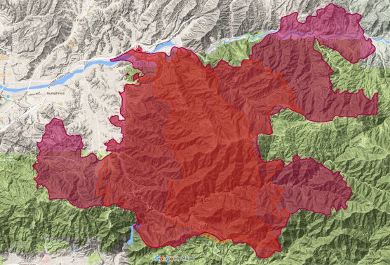
As temperatures rise and the potential for winds increases, Sand Canyon and Placerita Canyon remain at risk, as well as Soledad Canyon, and moving into Agua Dulce and Acton. Residents in Sand Canyon and Placerita Canyon should remain vigilant, and residents of Soledad Canyon, Agua Dulce, and Acton should remain on high alert.
On the south end, Placerita Canyon Rd and Little Tujunga Canyon Rd will remain closed. Placerita Canyon Rd between the 14 Freeway and Pacy will remain a hard closure.
* Evacuations encompass approximately 10,000 homes and 20,000 residents
* 200 Commercial buildings threatened
* 1 fatality (civilian)
The Sand Fire has burned 33,117 with 10% containment. Winds will be out of the Southwest at 30 mph picking up in the afternoon. Fire behavior is expected to be similar to previous days. The fire is passive when winds remain low in the morning. Fuels are responding to the the 5-year drought, low humidity, and extreme temperatures which causes the fire to move quickly.
Damage assessment teams are carefully evaluating impact to structures from yesterday’s firefight. As soon as the updated information becomes available, it will be provided. Currently, there are 18 structures destroyed and 1 damaged.
Personnel: 2,964
Crews: 43
Engines: 356
Dozers: 14
Water Tenders: 16
Helicopters: 26
Rapid Extraction Team: 2 (Firefighter rescue)
Injuries: 2 firefighters minor
770 Large animals currently in the care of Los Angeles County Animal Care and Control. Large animals can go to Hanson Dam, Pierce College, Antelope Valley Fairgrounds.
Small animals can go to Hart High School and Highland High School
Instructions:
Fire behavior will be extreme today as winds pick up out of the SW at 30 mph in the afternoon. Please comply with evacuation orders. Large animals should be evacuated early in the am to avoid congestion and allowing access to firefighting equipment.

Photo by Ken Lubas
U.S. Forest Service, Monday 4:15 p.m.:
URGENT – Fire is flaring up on Running Horse Lane North of Placerita Canyon Road. Residents in this area of Sand Canyon were previously ordered to evacuate when the Sand Fire initially impacted the Sand and Placerita Canyons on Saturday, July 23, 2016 at approximately 3:15 pm.
Residents who are able to safely evacuate should do so; however, it may be necessary to shelter in place.
Red Cross Hotline: 310-943-5228
The Sand Fire is approximately 33,117 acres and 10% contained. United States Forest Service, Los Angeles County Fire and Los Angeles County Sheriff’s Office are in “Unified Command.” Evacuations are in place. Over 2964 firefighters are engaged in initial attack. Resources include 356 engines, 43 hand crews, 16 water tenders, 26 helicopters and 14 dozers. The Incident Command Post is located at Golden Valley High School.
MANDATORY EVACUATIONS:
East of the 14 Freeway, from Golden Valley Road to Sand Canyon Road, excluding the Sand Canyon Mobile Home Park (residents to evacuate; commercial businesses to shelter in place)
East side of Via Princessa from Lost Canyon Road to end of Via Princessa and all streets east.
Lost Canyon Road from Via Princessa to the Santa Clara River, and all streets to the east.
Sierra Highway @ Shady Lane to Sierra Hwy at the 14.
Escondido at the 14 to Sierra Hwy at the 14.
Agua Dulce Canyon Road north to the 14 Freeway.
Crown Valley Road north to the 14 Freeway.
Soledad Canyon Road between Agua Dulce & Crown Valley.
All residents in Sand Canyon from Lost Canyon to Bear Divide.
All residents in Placerita Canyon from the Nature Center to Sand Canyon.
ROAD CLOSURES:
Sand Canyon and Soledad Canyon – no entry into Sand Canyon.
Little Tujunga as Osborne.
No access to Sand Canyon at northbound 14 Freeway.
Sand Canyon and Lost Canyon – no traffic into Sand Canyon.
Placerita Canyon and the 14 Freeway – no traffic into Placerita Canyon.
14 Freeway Northbout to Ward Road.
Soledad Canyon Road eastbound from the 14 Freeway.
Agua Dulce Canyon Road eastbound from the 14 Freeway.
Crown Valley Road eastbound from the 14 Freeway.
Sand Canyon Road east of Placerita Canyon to 12300 Little Tujunga.
Crown Valley as Escondido.
Escondido easti of 14 Freeway.
EVACUATION CENTERS – 1-800-775-5288:
Highland High School 39055 25th Street West, Palmdale, 93551
Hart High School, 24825 N. Newhall, Santa Clarita, 91321
Lakeview Terrace Recreation Center, 11075 Foothill Blvd, Lakeview Terrace, 91340
LARGE ANIMAL EVACUATION:
Antelope Valley Fair Grounds 2551 W. Avenue H. Lancaster CA 93536
Recent drone activity has occured over the fire in the Bear Divide Area. When drones interfere with firefighting efforts, a wildfire has the potential to grow larger and cause more damage. On the Sand Fire, an FAA Temporary Flight Restriction (TFR) is in effect and any private aircraft or drone that violates the TFR could face serious criminal charges. Even without a TFR, anyone who hampers firefighting efforts could face charges. For more information on drones the public can visit the FAA’s website atwww.KnowBeforeYouFly.org. “If you fly, we can’t!”
AIR QUALITY:
South Coast AQMD issued a Smoke Advisory effective today until midnight tomorrow based on unhealthy air quality conditions as a result of the Sand Fire. Smoke is moving toward the south east and multiple areas near the San Fernando and San Gabriel Valleys will be directly impacted. You can find a list of the areas on the AQMD website or follow them onTwitter
The Sand Fire is in Unified Command with United States Forest Service, Los Angeles County Fire Department and Los Angeles Sherri’f Department
Basic Information
| Current as of |
7/25/2016, 4:14:37 PM |
| Incident Type |
Wildfire |
| Cause |
Under Investigation |
| Date of Origin |
Friday July 22nd, 2016 approx. 02:15 PM |
| Location |
Northbound Hwy 14/Sand Canyon |
| Incident Commander |
So Cal Team 3 Michael Wakoski IMT 3, Chief John Tripp, LACFD And Sgt. Roosevelt Johnson LACSD |
| Incident Description |
Wildfire |
Current Situation
| Total Personnel |
2,964 |
| Size |
33,117 Acres |
| Percent of Perimeter Contained |
10% |
| Fuels Involved |
Chaparral/Brush |
Current Weather
| Weather Concerns |
Red Flag Warning, High Temperatures, low humidity, high winds |
L.A. County Fire Dept., Monday 7 a.m.:
Location: Initial fire reported location: NB 14 FWY at Sand Canyon, Santa Clarita
Administrative Agency: Unified Command: LACoFD, ANF, and LASD
Acres Burned: 33,172 acres
Containment: 10 percent
Date/Time Incident Reported: July 22nd at 2:11 p.m.
Last Update: 7 AM 07/25
Total Personnel: 2,964 firefighters
Evacuation Center: Wiliam S Hart HS: 24825 Newhall Ave, Santa Clarita
Pierce College at 6201 Winnetka Ave, Woodland Hills is now accepting large animals.
Antelope Valley Fairgrounds is now open to accept large animals.
Hansen Dam has reached capacity of large animals.
Community Message Residents can now call 626-574-5208 to get Sand Fire updates throughout the day.
Mandatory Evacuations:
East of the 14 Freeway from Golden Valley Road to Sand Canyon Road, excluding the Sand Canyon Mobile Home Park (residents to evacuate; commercial businesses to shelter in place)
East side of Via Princessa from Lost Canyon Road to end of Via Princessa and all streets east.
Lost Canyon Road from Via Princessa to the Santa Clara River, and all streets to the east.
Sierra Highway @ Shady Lane to Sierra Hwy at the 14.
Escondido at the 14 to Sierra Hwy at the 14.
Agua Dulce Canyon Road north to the 14 Freeway.
Crown Valley Road north to the 14 Freeway
Soledad Canyon Road between Agua Dulce & Crown Valley.
All residents in Sand Canyon from Lost Canyon to Bear Divide / All residents in Placerita Canyon from the Nature Center to Sand Canyon / Little Tujunga from Bear Divide to LA River Ranger
District (Station), 12371 Little Tujunga Cyn Rd.
Reentry Information: South of Santiago to Crown Valley between Soledad and the 14 FreewayWest of the 14 Freeway between Escondido and Ward Road
Like this:
Like Loading...
Related


 Tweet This
 Facebook
 Digg This
 Bookmark
 Stumble
 RSS
RSS


REAL NAMES ONLY: All posters must use their real individual or business name. This applies equally to Twitter account holders who use a nickname.
23 Comments
Daniel Miranda
Maybe you shouldn’t go to work today.
I left a while ago.
We are on the far left of this map.
We are actually not on this map, my house is the closest which is about 4 miles away.
We are above it, over the hill in sleepy valley.
Hello Tru . Do you feel the fire can make it over to you ? My mother in law is across the way from the Agua dulce winery on Sierra hwy.
Scary?
Ernie
Erin Kenneally well the fact that there is that big white area gives a little hope right?
Absolutely!
Steph Estrada
Would be good to get more specific boundaries, which streets/ highways exactly, trying to figure it out is too inaccurate from this map. I know the fire keeps moving but still…
E.g. since Placerita Canyon is closed #the 14 and it mentions areas off La Princessa/ Sierra, is Scenic Hills Newhall being evacuated or on close watch? What about Friendly Valley next to it, both Newhall, with a lot of older people? I know people there.
— What’s the western edge of the danger zone?
The 12:02 version has a map that can be zeroed down to the critical areas but it’s hours old now, would be good to get detailed map from the local paper here. So far the 14 seems to be the barrier but the mall @Golden Valley is in the danger zone, Kohl’s etc., I hope they’re wetting down their buildings!
— Anyone who has to evacuate should soak their homes first if they can, turn on sprinklers — that’s what a firefighter told me to do once.
— Ash keeps falling in Stevenson Ranch, friends as far away as Santa Monica and Culver City have been seeing smoke and some have ash too, thank god for the firefighters from all over!
— The story about Animal Control saving 750+ animals makes you realize there are kind people out there, that total includes 111 chickens as well as horses and goats, then there’s the Wildlife Station.
Hmm.. a detailed map from the local paper? The local paper gets their stuff from us … BTW we’re getting calls from people who are smelling our smoke in Arizona
Santa Clarita my prayers are with you
Is your mom back from Vegas yet?
Terrible
God bless you .
I was in Palmdale today; very hot, windy and smoky. Came home with a sore throat. Pray for the firefighters and residents
So frightening for everyone …prays to the firefighters
God Bless them !