header image

[Sign Up Now] to Receive Our FREE Daily SCVTV-SCVNews Digest by E-Mail

Inside
Weather


Calendar
Today in
S.C.V. History
May 6
1971 - Fort Tejon added to National Register of Historic Places [story]
Fort Tejon


Commentary by Mike Summe
| Thursday, Oct 27, 2016

mikesummeWhen I moved to California in 1977, I settled in the flatlands of the L.A. basin and stayed there for the next 35 years, paying scant attention to the mountains. In 2012, I retired and started hiking and biking into the mountains that separate my home in Shadow Hills from Santa Clarita. I kept running into strange, fenced-in sites, usually located at the top of cul-de-sacs.

Each site consisted of a pit that ended at a concrete wall. Close to the wall, a strange perforated silo would rise up. On the locked gates hung two signs. One warned against trespassing. The other declared the site was under the control of the Los Angeles County Department of Public Works and gave what appeared to be the name of the site — often the name of the street followed by the abbreviation “D.B.”

It turned out that “D.B.” means “debris basin.” There are 172 in Los Angeles County, including 33 in the Santa Clarita Valley. My purpose here is to share some basic facts about these important structures and give you some leads if you’d like to do some exploration of your own.

What is a debris basin? One website (www.fws.gov) defines a debris basin as a “specially engineered and constructed basin for storing large amounts of sediment moving in an ephemeral stream channel.” The DPW provides a more helpful definition: “Debris basins are instrumental components of the flood control system. Typically located at the mouths of canyons, debris basins capture the sediment, gravel, boulders, and vegetative debris that are washed out of the canyons during storms. The debris basins capture the material and allow the water to flow into the downstream storm drain system.”

debrisbasin02Each debris basin typically consists of an excavation that begins at the bottom of a canyon and terminates at a dam. Near the dam is a “perforated silo” made of corrugated metal, sometimes concrete. The DPW calls these silos “the outlet works.” Their purpose is to allow the water to flow past (under) the dam, even when a considerable amount of debris has accumulated in the basin. The paved spillway on the downhill side of the dam helps control the water that flows under or, on occasion, over the dam.

The debris basins may also contain a number of less visible features including a porous basin that allows water to soak into the ground and a well that stores water that can later be pumped into the public water supply. In the hills above the debris basins, one may find check dams and other structures that direct water into the canyon.

Not all debris basins have all of these features; the oldest ones didn’t separate the water from the debris. As for size, most debris basins “are associated with small catchments and … are commensurately modest, with capacities under 100,000 cubic yards.” The smallest one I’ve seen is the Camp Plenty debris basin in Canyon Country; a larger, more complete one is the Wedgewood debris basin in Castaic.

What is the purpose of debris basins? The answer is best explained as the interaction of two inexorable forces. The first is the geology of Los Angeles. The mountains that dominate our landscape are among the youngest and most rapidly rising on Earth and the most unstable. As John McPhee points out in his well-known essay, “Los Angeles Against the Mountains,” the San Gabriel Mountains are “shedding, spalling” and “disintegrating at a rate that is … among the fastest in the world.” The second inexorable force is people. Los Angeles County has a population of more than 10 million, and we all know that more and more houses are being built in the mountains and foothills. There are plenty of recent examples in the Santa Clarita Valley.

What happens when these two forces interact is explained by the DPW: “Although the weather in Southern California has often been described as the best to be found anywhere, it is capricious and capable of producing enormous flood devastation. Storms, moving in from the Pacific generally from October to March, come up against the numerous steep mountain ranges that ring Malibu, the Los Angeles Basin, and the Antelope, San Fernando, San Gabriel and Santa Clarita Valleys. These storms frequently produce enormous amounts of runoff that spill out onto the flatlands leading to the Pacific Ocean or Mojave Desert. And if the age-old fire sequence has occurred along the hillsides during the dry months, the rate, composition and amount of runoff are substantially increased. Since the geological composition of the mountain ranges erodes quite easily, a heavy mix of debris is added to the descending storm waters.”

John McPhee gives a vivid description of what the DPW calls “a heavy mix of debris.” Debris flows, McPhee explains, “more or less resemble fresh concrete. They consist of water mixed with a good deal of solid material, most of which is above sand size. Some of it is Chevrolet size.” His automotive metaphor is not inappropriate, for in his description of a specific event, he tells how a mudslide “was not only full of boulders; it was so full of automobiles it was like bread dough mixed with raisins.” Making matters worse, the mudslide was fast enough to overtake a number of residents who tried to flee downhill in their cars.

How effective are the debris basins? Although man cannot control the mountains of Los Angeles, John McPhee admits: “Generally, the debris basins work.” But they are not 100 percent effective, and debris basins can and have been overwhelmed – sometimes with catastrophic results. Also, debris basins are expensive – not only to build, but also to maintain.

debrisbasin01To function properly, the debris must regularly be cleaned out, which not only requires expensive contracts, but also raises the question of where the debris goes. It is easiest if the site is nearby, but you probably won’t be surprised to learn this is not always popular with residents. Sometimes the debris, which in the absence of man’s intervention would have washed down to the ocean, is hauled in the opposite direction over the mountains. McPhee explains the irony: “Now there is a beach problem. Sand is being lost to offshore canyons and is not being replenished. … A place that values its beaches as much as Southern California does has no choice but to buy sand.” And people can be picky. “When 30,000 yards of sand was put on Zuma Beach, people complained that it was the wrong color.”

A short history. In the early days, “there was a moat of oranges between the built-up metropolis and the mountain front.” However, when wildfires in late 1913 were followed by heavy rains and a flood in early 1914, it was clear that more protection was needed. The government responded quickly. In 1915, the California Legislature created the Los Angeles County Flood Control District. One of its first projects was the Devil’s Gate Dam, built in 1920 to control the Arroyo Seco. A few years later, nature again delivered its one-two combination. At the end of 1933, wildfires denuded the slopes above Pasadena, La Cañada, La Crescenta and Montrose. Then on New Year’s Day, a “Noah-type storm” struck, mobilizing “a number of almost simultaneous debris flows that came out of the mountains, went through the orchards and into the towns, killed dozens of people, destroyed hundreds of houses, and left boulders the size of icebergs.”

There was ironically an unexpected benefit to this disaster. People noticed that a gravel pit in Haines Canyon above the village of Tujunga had swallowed the debris flow that would otherwise have wiped out the community. According to McPhee, this gravel pit became the inspiration, the model for all debris basins.

Be that as it may, a number of debris basins were built on the southern slopes of the San Gabriels in the aftermath of the 1934 mudslides. On a website maintained by the U.S. Geological Survey, I found the dates of initial operation for 75 of Los Angeles County’s 172 debris basins. Fifteen were built in the immediate aftermath of the 1934 flood, all in the area of that flood. Seven more were built in the 1940s; again, most were built on the south-facing slopes of the San Gabriels in the greater Pasadena area, but one was built as far west as Northridge and another as far east as Brea. Nineteen were built in the 1950s, with most on the south-facing slopes above Foothill Boulevard, but with one in Whittier, one in the Verdugos and a few in the San Fernando Valley. Twenty were added in the 1960s, some in the core area but others extending out to Glendora and one in Newhall — the Wildwood debris basin on Davey Avenue. The USGS website identified 12 debris basins built between 1970 and 1975; however, there was no information for subsequent years, so I do not have operation start dates for the other 97 debris basins.

My guess is that the 97 undated debris basins were built after 1975. Why do I say this? Because the information I do have suggests the building of debris basins occurred in step with the development of housing tracts in or near the mountains. My sense is that the earliest residential development occurred in the greater Pasadena area where the earliest debris basins are located. It also seems that the order in which additional debris basins radiated from Pasadena between 1940 and 1975 follows the same timeline as residential expansion. Many of the undated debris basins are located in areas where large-scale building occurred still later.

To the east, the communities with debris basins for which I have no dates include Monrovia, Duarte, Glendora, Rowland Heights, Diamond Bar; to the west, Canoga Park, Calabasas, Malibu; and to the north, Santa Clarita, Castaic and Palmdale.

As part of my research, I visited five debris basins in the hills along Hillcrest Parkway in Castaic. The neighborhoods are obviously newly built, and at the end of the cul-de-sacs that mark the uphill limit of development, I found the debris basins. My conclusion? They were built contemporaneously with the housing tracts. Am I right? I won’t know for sure until I find the start dates. If anyone can provide me with such dates or point me in the right direction, please send me the information.


Mike Summe is a docent at the Placerita Canyon Nature Center and a retired high school principal.

Comment On This Story
COMMENT POLICY: We welcome comments from individuals and businesses. All comments are moderated. Comments are subject to rejection if they are vulgar, combative, or in poor taste.
REAL NAMES ONLY: All posters must use their real individual or business name. This applies equally to Twitter account holders who use a nickname.

4 Comments

  1. Very interesting Mike. Thanks.

  2. Julio Diaz says:

    Fantastic read, thank you Mike :)

  3. Great, Mike. Tried to share this in Placerita fb page, failed.

  4. Tina White says:

    I talk about these in the college geography courses I teach; thank you for an interesting new assigned reading for my students!

Leave a Comment


Opinion Section Policy
All opinions and ideas are welcome. Factually inaccurate, libelous, defamatory, profane or hateful statements are not. Your words must be your own. All commentary is subject to editing for legibility. There is no length limit, but the shorter, the better the odds of people reading it. "Local" SCV-related topics are preferred. Send commentary to: LETTERS (at) SCVNEWS.COM. Author's full name, community name, phone number and e-mail address are required. Phone numbers and e-mail addresses are not published except at author's request. Acknowledgment of submission does not guarantee publication.
Read More From...
RECENT COMMENTARY
Thursday, May 2, 2024
As we kick off the new month, I am proud to reflect on the incredible growth and achievements we've witnessed over the past four months.
Thursday, May 2, 2024
With spring in full effect, now is the best time to hit the trails and enjoy the natural scenery of Santa Clarita.
Wednesday, May 1, 2024
Imagine a day where barriers dissolve and possibilities unfold, a day dedicated to celebrating diversity and fostering inclusivity.
Monday, Apr 29, 2024
At the Los Angeles County Board of Supervisors meeting this week, we reviewed the Chief Executive Officer's proposed $45.4 billion budget for the next fiscal year.
Thursday, Apr 25, 2024
Spring heralds a time of renewal and rejuvenation, not just in the natural world, but within our homes and lives as well.
Tuesday, Apr 23, 2024
Los Angeles County Fifth District Supervisor Kathryn Barger issued a statement in support of the Los Angeles County Chief Executive Officer’s presentation of a $45.4 billion budget for the forthcoming 2024-25 fiscal year.

Latest Additions to SCVNews.com
1971 - Fort Tejon added to National Register of Historic Places [story]
Fort Tejon
Dale Donohoe and Kim Kurowski were named the Santa Clarita Valley's top volunteers of the year at the 2024 SCV Man and Woman of the Year dinner celebration held Friday, May 3 at the Hyatt Regency Valencia. The event also honored all of the 17 men and 17 woman nominated for the award.
Donohoe, Kurowski Named 2024 SCV Man, Woman of the Year
1828 - Soledad Canyon settler John Lang born in Herkimer County, N.Y. [story]
Lang
1903 - President Teddy Roosevelt visits Gov. Henry Gage at Acton Hotel [story]
Acton Hotel
The regular meeting of the Saugus Union School District Governing Board will take place Tuesday, May 7, with closed session beginning at 5:30 p.m., followed immediately by public session at 6:30 p.m.
May 7: Regular Meeting of the Saugus School Board
The city of Santa Clarita Arts Commission is holding its regular meeting in City Hall's Council Chambers Thursday, May 9 at 6 p.m. The meeting will be held at Santa Clarita City Hall, 23920 Valencia Blvd., Valencia, CA 91355.
May 9: Arts Commission to Hear Updates on Civic Art Projects
Experience the Butterfly Encounter at Gilchrist Farm open now on weekends thorugh Sunday, June 18. Walk through a tent of beautiful flowers hosting live butterflies that fly freely throughout the tent.
Experience the Butterfly Encounter at Gilchrist Farm
The Santa Clarita Community College District Board of Trustees will hold a business meeting Wednesday, May 8, beginning at 5 p.m. The board will first meet in closed session at 4:15 p.m.
May 8: COC Board Business Meeting Considers Contracts
The Castaic Union School District Governing Board will hold its regular meeting Thursday, May 8, at 6 p.m. A closed session will be held at 5:30 p.m.
May 8: Castaic Union School Board Regular Meeting
Fire Service Day Open House will be held at all County of Los Angeles Fire Department fire stations on Saturday, May 4 from 10 a.m. to 5 p.m.
May 4: LACoFD Hosts Countywide Open House at All Fire Stations
The Santa Clarita Valley Media Collaborative invites the public as well as local creatives, media industry professionals, students, parents, teachers and others to celebrate the next generation of media makers participating in the inaugural NextGen MediaMakers Festival on Saturday, May 18 from 2-5 p.m. at the Canyon Country Community Center.
May 18: Support Young Creatives at NextGen MediaMakers Festival
Explore Vasquez Rocks during the magical twilight and early evening full moon hours. These fun, collaborative, interpretive hikes are led by trained staff and volunteers and will highlight the park's natural and human history.
Vasquez Rocks Full Moon Twilight Hikes
Astrotourism is top of mind for travelers making special trips for experiences in the sky, and with the recent “take-your-breath-away” total solar eclipse, thousands of cruisers onboard Emerald Princess and Discovery Princess off the coast of Mexico caught a glimpse of the total darkness event.
Princess Cruises Sails to Prime Viewing Spot for 2026 Total Solar Eclipse in Europe
The Santa Clarita City Council will hold a study session on Tuesday, May 7 at 5 p.m. The council will meet at City Hall, Carl Boyer Room, 23920 Valencia Blvd., First Floor, Santa Clarita, CA 91355.
May 7: City Council Conducts Budget Study Session
Garbage inspectors will soon be paying a visit to neighborshoods throughout the Santa Clarita Valley to inspect recycling bins to insure residents are following the recycling rules in the SCV.
Garbage Inspectors to Look for Improper Recycling
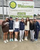
College of the Canyons competed at the 3C2A State Singles & Doubles Championships for a second straight year, with the doubles duo of Sydney Tamondong and Estrella Segura establishing program history by advancing to the round of 16 at the Ojai Athletic Club.
Canyons Advances to Day 3 of 3C2A State Championships
College of the Canyons men's basketball head coach Howard Fisher's Cougar Basketball Camp returns in 2024 with three sessions open to boys and girls ages 8 to 14.
Registration Open for 2024 Howard Fisher Cougar Basketball Camp
The Friends of Santa Clarita Public Library is hosting a “Spring Bag Sale” event at the Valencia, Canyon Country and Newhall branches of the Santa Clarita Public Library, during normal operating hours from Saturday, May 4 to Sunday, May 12.
May 4-12: Spring Bag Sale at Santa Clarita Public Library
A former public school teacher who launched a racist and anti-immigrant tirade against a Santa Clarita street vendor is being sued by a Latino civil rights group for civil assault and violating California civil rights laws.
MALDEF Sues Man After Rant at Fruit Vendor in SCV
The Village of Pine Mountain Club has hosted wine festivals since 2003. You can taste exciting wines from the world’s top wine-growing regions, with dozens of premier wineries to choose from on Saturday, July 6, 1-4 p.m. at Wine in the Pines.
July 6: Wine in the Pines, Pine Mountain Club
1842 - California's first mining district established in SCV; Ygnacio del Valle, chairman [story]
Ygnacio del Valle
The American Cancer Society Relay For Life of Santa Clarita Valley will be held Saturday, May 4, 9 a.m.-9 p.m. at Central Park, with the theme “May The Cure Be With You,” a Disney/Star Wars celebration.
May 4: SCV Relay for Life ‘May the Cure Be With You’
Ten risk-taking, mid-career artists were announced Thursday as the recipients of the 2024 Herb Alpert Award in the Arts (HAAIA).
CalArts Announces 2024 Herb Alpert Award Winners
CEDAR RAPIDS, Iowa -- The Master's University men's volleyball team won their opening match of the 2024 NAIA National Championship with a 3-set win over the No. 9-seed Mount Mercy (IA) Mustangs.
Mustangs Post-Season Play Continues After First Round Win
SCVNews.com