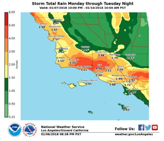
A strong cold front moving into Southern California will collide with subtropical moisture and bring moderate to heavy rainfall from Monday afternoon through Tuesday morning, according to the National Weather Service.
The service has issued a flash flood watch for recent burn areas of Southern California including the Santa Clarita Valley from 10 p.m. Monday through 10 p.m. Tuesday.
At the same time, the NWS issued a wind advisory from 8 p.m. Monday until noon Tuesday, warning of strong and potentially damaging wind across the region.
Gusts up to 60 mph will be possible across much of the watch area, with gusts up to 70 mph possible across the mountains, including Interstate 5 near the Grapevine.
Rainfall in excess of one half to an inch per hour is possible during the peak of the storm.
There is a strong potential for flash flooding and mud and debris flow in and around the burn areas of the Creek, La Tuna, Skirball, Rye and Fish fires.
Residents in or below the recently burned areas are urged to take the steps necessary to protect their property. Those in the watch area should remain alert and follow directions of emergency preparedness officials.
A winter storm watch has also been issued for the mountains of Los Angeles and Ventura counties due to the potentially damaging wind in upper elevations.
Behind the cold front, scattered showers and isolated thunderstorms will continue through Tuesday evening.
Like this:
Like Loading...
Related


 Tweet This
 Facebook
 Digg This
 Bookmark
 Stumble
 RSS
RSS


REAL NAMES ONLY: All posters must use their real individual or business name. This applies equally to Twitter account holders who use a nickname.
0 Comments
You can be the first one to leave a comment.