|
|
|
|
|
|
The College of the Canyons Aerospace and Science Team has received a $300,000 grant from NASA’s Mentoring and Opportunities in STEM with Academic Institutions for Community Success program.

|
Bring along a furry friend to the Santa Clarita Child & Family Center's Purple Walk Domestic Violence Awareness 5K on Saturday, Oct. 5 from 8-11 a.m. at the Center’s main facility 21545 Centre Pointe Parkway, Santa Clarita, CA 91350.

|
Written and directed by Braddon Mendelson, produced by Heather Mendelson, and co-produced by Olive Branch Theatricals and Noisivision Studios, "Provenance" will take stage at the The MAIN, 24266 Main Street, Santa Clarita, CA 91321, Friday through Sunday, Sept. 27-29.

|
The Master's women's volleyball team opened Great Southwest Athletic Conference play on the road in Prescott, Ariz. on Wednesday, Sept. 18, defeating the Embry-Riddle Aeronautical University Eagles in straight sets 28-26, 25-22, 25-18.

|
College of the Canyons freshman Sahya Kitabatake shot a two-under-par round of 70 to tie for medalist honors while helping the Cougars place fourth at the Western State Conference tournament at Sterling Hills Golf Club in Camarillo on Monday, Sept. 16.

|
One of the city of Santa Clarita community’s most cherished parks, David March Park is set to expand, Thursday, Sept. 26, at 10 a.m., 28310 North Via Joyce Drive, Santa Clarita, CA 91350 with a groundbreaking ceremony.

|
SRD Straightening Reigns, a therapeutic organization offering equine assisted psychotherapy, has been awarded $278,870 from the California State budget to improve mental health services.

|
The Santa Clarita Community College District Board of Trustees appointed Carlos Guerrero to fill the board seat in Area 5, effective immediately, at its special Wednesday, Sept. 18 meeting.

|
California Institute of the Arts alums Alyssa Dressman Lehner and Clara Plestis captured Emmy Awards at the 76th Primetime Creative Arts Emmy Awards.

|
Valencia High School's Choir will hold a fall concert, "Broadway, Movies & Media" at 7 p.m., Thursday, Sept. 26 at 7 p.m. and Friday, Sept. 27, 7 p.m. at the Saugus High School Theatre, 21900 Centurion Way, Santa Clarita, CA 91350.

|
As my wife, Virginia, and I stroll through our magnificent city, we admire the beautiful paseos and the expansive open spaces, but what really catches our eye, is the diverse works of art at every turn.
|
The California Department of Public Health is encouraging all Californians to get vaccinated this season to protect themselves and loved ones from respiratory viruses.

|
The Friends of Santa Clarita Public Library in collaboration with Santa Clarita Valley Libraries will have a silent Book Auction beginning at 9 a.m. Monday, Sept. 30, through 10 a.m. on Monday, Oct. 7.

|
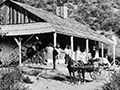
1863 - Gen. Edward F. Beale loans money to A.A. Hudson and Oliver P. Robbins to erect toll house in Newhall Pass [ story]
|
The Counties of Los Angeles and San Bernardino today announced the opening of multiple joint Local Assistance Centers to assist residents impacted by the Bridge and Line Fires.

|
Valencia Gynecology Associates, owned by longtime Santa Clarita Valley OB-GYN physician Don Nishiguchi, MD, has joined the Henry Mayo Newhall Hospital network.

|
JCI Santa Clarita is proud to announce the upcoming Veteran’s Resource Fair, scheduled to take place on Sept. 21 at William S. Hart Park.

|
A "friendies" field tournament is being hosted by the Saugus Instrumental Music program, with support from Valencia High, later this month.

|
Public, member-supported 88.5 FM The SoCal Sound, Southern California’s leading Triple-A (adult album alternative) format radio station has announced the lineup for its inaugural “Year-End Bash” taking place on Saturday, Dec. 7.

|
The Master's University cross-country teams continued their successful 2024 campaigns with strong finishes at the BIOLA Invitational on Friday, Sept. 13 at Craig Regional Park in Fullerton, Calif.

|
Sheriff’s Department Announces New Law Enforcement Gang Policy

|
The biology department at California State University, Northridge has stayed committed to promoting STEM research carried out by K-12 students and teachers in the Los Angeles Unified School District.

|
Did you know the SCVEDC has an interactive, online tool that provides themed virtual tours of the amazing features the community has to offer?

|
California Institute of the Arts alum and visionary filmmaker Tim Burton (Film/Video 1979) was honored with the 2,788th star on the Hollywood Walk of Fame.

|


 Tweet This
 Facebook
 Digg This
 Bookmark
 Stumble
 RSS
RSS


REAL NAMES ONLY: All posters must use their real individual or business name. This applies equally to Twitter account holders who use a nickname.
1 Comment
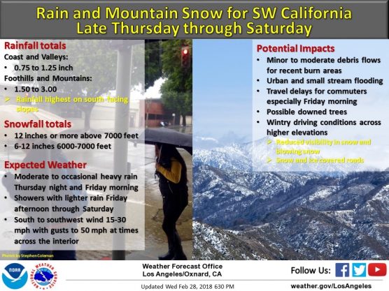
Awesome – I Love Rain – Seeing Hills – Mountains Thrive