Arcadia – The Angeles National Forest will temporarily shut down high-use portions of the San Gabriel Mountains National Monument and Los Angeles Gateway Ranger District, effective April 4 through April 30.
The closure is in alignment with current federal, state and local guidance for social distancing during the COVID-19 pandemic and to ensure the health and safety of National Forest visitors, volunteers and employees.
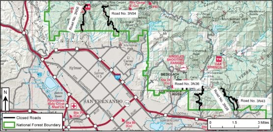
The closure includes four formal trailheads and 23 informal trail access points, resulting in a larger closure of 23 trails and 19 roads. In total, this results in closure of 81.5 miles of trail (out of 760 open miles) and 54.5 miles of road.
The closure does not close the ability to walk on to National Forest System land but does restrict access to roughly 40,000 out of 700,000 acres of the Angeles.
These closures will address public health and safety concerns to trail-related recreation. A violation of this prohibition is punishable by a fine of not more than $5,000 for an individual or $10,000 for an organization, or imprisonment for not more than six months, or both. (Reference 16 USC 551 and 18 USC 3559, 3571, and 3581. Forest Order No. 05-01-20-03.)
The USDA Forest Service may need to temporarily suspend access to additional recreation areas that attract large crowds and cannot meet social distancing guidelines recommended by the Centers for Disease Control and Prevention.
Visitors to national forests are urged to take the precautions recommended by the Centers for Disease Control and Prevention (CDC) so that these areas can remain open for everyone’s enjoyment.
See the complete list below.
To protect public health and safety all visitors to the forest are encouraged to:
• Avoid visiting the forest if you are sick and/or experiencing COVID-19 symptoms.
• Follow CDC guidance on personal hygiene and social distancing before and during your visit to the forest.
• If an area is crowded, move to a less occupied location. Also consider avoiding the forest during high-use periods.
• Take your trash with you when you leave. Trash overflowing the receptacles becomes potential sources for the spread of COVID-19.
• Please make arrangements to use the restroom before or after your visit to the forest. Unmanaged waste creates a health hazard for other visitors and employees.
Information from the U.S. Department of Agriculture is available at www.usda.gov/coronavirus.
For up-to-date information on the Angeles National Forest, visit https://www.fs.usda.gov/angeles/.
The following trails and access points to trails are closed:
Trailheads:
Millard
San Antonio Falls (Baldy Bowl)
Icehouse Canyon
North Devil’s Backbone
Trails:
1311W13 KENYON DEVORE
1311W14 GABRIELINO NRT
1311W22 MT. WILSON
1311W28 RIM TRAIL
1312W09 VALLEY FORGE
1312W14.1/.2/.3 SAM MERRILL TRAIL
1312W18/.1 SUNSET RIDGE
1312W24 SAN GABRIEL PEAK
1312W27 EL PRIETO
237W08 ONTARIO PEAK TRAIL
237W12A BEAR CANYON LOOP TRAIL
237W05 DEVILS BACKBONE TRAIL
237W06A TELEGRAPH PEAK TRAIL
237W12 MT. BALDY TRAIL
237W08A BIGHORN PEAK TRAIL
237W07 CHAPMAN TRAIL
237W06B TIMBER MTN TRAIL
237W07A ICEHOUSE CANYON TRAIL
237W06 THREE T’s TRAIL
237W02 BALDY BOWL TRAIL
337W05.2 NORTH DEVIL’s BACKBONE
238W09 JOATNGA INTERPRETIVE LOOP TRAIL
337W01 ACORN
Roads:
2N40 BIG SANTA ANITA
2N45.1/.2 MT. WILSON TOLL RD.
2N50.1/.2 MT. LOWE
2N52 DISAPPOINTMENT RIDGE
2N65.1 MILLARD CANYON RD.
2N65.2 CHANNY TRAIL
2N66 BROWN MTN
2N68.1/.2 MALLARD RIDGE RD.
2N69 GOULD MESA
2N70.1 ARROYO SECO RD.
2N76.1/.2/.3 MT LUKENS RD.
2N81.1 EARL CANYON MOTORWAY
3N36 BPL No.1 (OLIVER RD.)
3N38.1/.2 DOANE EBEY RD.
3N43 DOANE CANYON RD.
3N54 MAY CANYON RD.
3N56 WILSON CANYON RD.
1N04A POTATO MTN SPUR
1N04 PALMER-EVEY CANYON
Like this:
Like Loading...
Related


 Tweet This
 Facebook
 Digg This
 Bookmark
 Stumble
 RSS
RSS


REAL NAMES ONLY: All posters must use their real individual or business name. This applies equally to Twitter account holders who use a nickname.
1 Comment
I live in lytle creek ca. This is in san bernadino county. This area is busy with people who like to spend the day by the creek and hike up to the waterfall. I was surprised to see alot of people wondering around the area picnicking and hiking as usual. We have been following the recommendations to help contain this horrible virus. I felt disappointed to see the # of people who drove up here this w/e. I am concerned and upset that these people were allowed to come into the area where we live and possibly bringing this virus to an area that we are following the suggested protocols to help to slow the spread. I did not see the lytle creek community and creek listed. I would like to see it closed as it is a high use area just as the closed community of mt. Baldy which is close to us. I am happy and believe that these closures are needed.I also understand that this virus can live in water for days to weeks. People who are unknowingly shedding the virus could possibly infect our creek and even our ground water this really concerns me as we are on well water. I know the likelyhood of this happening is low….but it is possible well water is not treated like municipal water is and let’s face it we do not know enough about this virus to take chances that could cost someone their life. I’m not sure where or to whom I can make a plea to close the lytle creek area. Thank you Pamela Smith