The Los Angeles County Board of Supervisors will hear comments from the public about the proposed Centennial Specific Plan Project at their next meeting on Tuesday, Dec. 11, starting at 9:30 a.m.
Following public comments, the Supervisors are expected to certify the Centennial Plan’s Final Environmental Impact Report, including the water supply assessment, and adopt additional resolutions and permits to clear the path for the project’s development by Tejon Ranch Co.
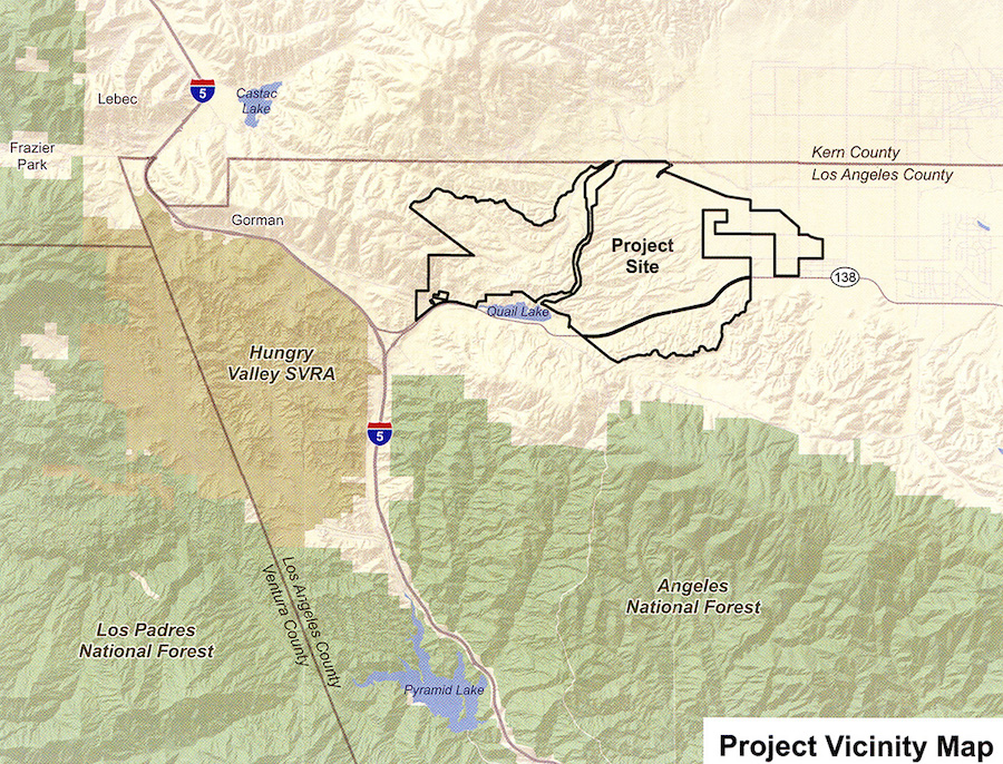
Approved by the LA County Planning Commission last summer, the proposed Project No. 02-232-(5) would develop a master-planned community on the edge of the Mojave Desert at Tejon Ranch, about 60 miles north of Los Angeles, to include up to 19,333 dwelling units on 4,987 acres of land designed for residential uses.
Other land uses would include 7,363,818 square feet of Business Park uses (office, research and development, warehousing and light manufacturing uses) on 597 acres, and 1,034,500 square feet o=f commercial uses on 102 acres.
Proposed institutional/civic land uses (such as schools for higher education, medical facilities, library, and other civic uses) would encompass 1,568,160 square feet on 110 acres.
The Centennial project would include 130,680 square feet of recreation/entertainment overlay uses (clubhouse, farmers market, childcare facilities and health clubs) on 75 acres.
Proposed sites for major utility facilities that would serve the entire community (e.g., two wastewater reclamation facilities, water treatment facility, water bank, materials recovery facility) encompass 191 acres.
For the complete package of hearing documents, click here.
Tuesday’s meeting will be streamed live here.

Tejon Ranch from the Tehachapi Crest, with Frazier Mountain in the background. (RangerX via Wikipedia)
Like this:
Like Loading...
Related


 Tweet This
 Facebook
 Digg This
 Bookmark
 Stumble
 RSS
RSS


REAL NAMES ONLY: All posters must use their real individual or business name. This applies equally to Twitter account holders who use a nickname.
3 Comments
Water for how many families? More Gridlock? How is the ground water? What depth are wells and how much contamination?
Since when is Castaic Lake in Kern County and north of Gorman? I think someone messed up on the map.
That is the real Castaic Lake (the natural water body). You seem to be thinking of the so-called Castaic Lake that is actually the manmade DWR Castaic Reservoir. https://scvhistory.com/scvhistory/lw3063.htm