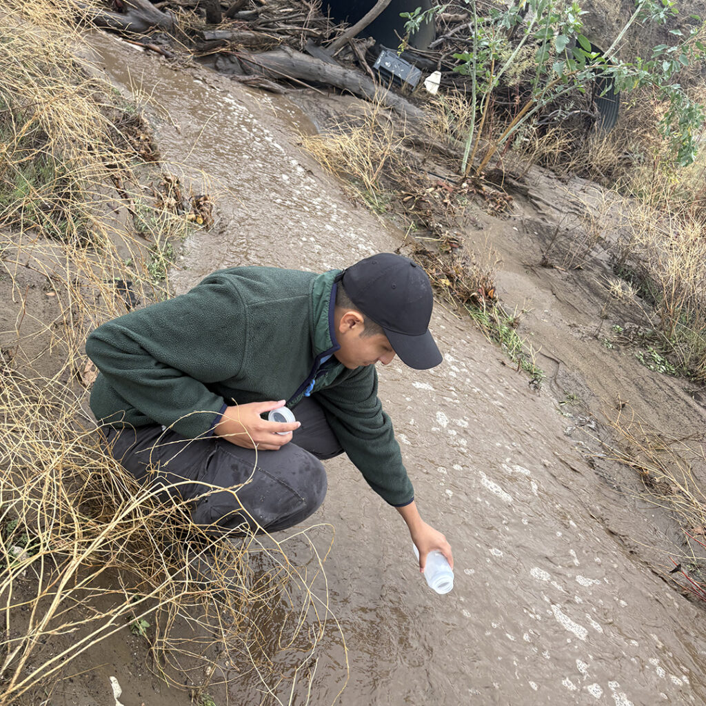
Armed with beakers, test tubes and multi-parameter water quality meters and velocimeters, a team of California State University, Northridge geography and environmental studies students, working alongside students from Cal State Long Beach, have spent the past few weeks scouring the burn areas of the Palisades, Eaton and Lake Hughes fires looking for natural rivers, streams, creeks and watersheds.
Once they find one, they collect water in a beaker, pour it into test tubes and, using one of their meters, measure it for a variety of things including turbidity, the kind particles in the water, its clarity, the velocity of the source where it was found and even its temperature. What they learn will go into a national database to help researchers better understand the impact the 2025 fires had on critical environmental characteristics, such as water turbidity. The database will serve as a baseline of information that can be used for future research.
“This is a year-long project,” said lecturer Hilary Taylor Johnson, a faculty member in CSUN’s Geomatics and Aerial Environmental Research Group in the College of Social and Behavioral Sciences who is supervising the Northridge students on the project. “Undergraduate and graduate students yare going out at least twice a week, sometimes several times a day, when we have heavy rains, and once a week during dry weather to test water. Initially, we were looking to collect information to help understand what affects water quality. But then we realize that the database we are creating can inform research across a number of fields, disciplines and research topics.”
Funded by the National Science Foundation, the study is a joint effort with the University of Texas at Arlington and Cal State Long Beach, in collaboration with NASA Jet Propulsion Lab. The project is being spearheaded by Adnan Rajib, director of the Hydrology & Hydroinformatics Innovation Lab in the Department of Civil Engineering at UT Arlington.
“California is very unique,” Johnson said. “We’ve had these horrible fires, a drought and we’re prone to extreme atmospheric rivers. All of which make it a great location to gather information to create a database. Dr. Rajib originally asked us to help him gather data to help him in his efforts to understand water quality that is in areas prone to landslides after the fires. Large fires are often precursors to landslides, and he is looking into implement a new water quality monitoring network to record the post-fire turbidity levels in surface streams in and around Los Angeles and will develop a novel AI model to identify the direct impact of fire on water quality.”
Johnson said as the group gathered more and more information, it realized that the data could have many applications.
“Particularly if it were put into a national database that could be accessed by researchers from around the country,” she said.
The researchers , Johnson said, “are hoping to paint a picture of the aftermath of the fires’ impact on the water: What’s in it, how fast it’s moving and a bunch of other information, while taking into account the drought and atmospheric rivers. We didn’t realize how big this was going to be until the team from Texas came out. We were all sitting at a creek, one of the test sites near JPL, when it hit us. This thing is going to be huge.”
Taking part in the project in an invaluable, hands-on research experience for the students, Johnson said.
“I always teach my students that educating the public is the most important thing when it comes to anything that we learn,” she said. “Just understanding the environment, just understanding the simple stuff of your environment in your area — the weather, the topography — all this really helps us to have a better understanding of how we can better prepare ourselves for certain situations.”
Like this:
Like Loading...
Related


 Tweet This
 Facebook
 Digg This
 Bookmark
 Stumble
 RSS
RSS


REAL NAMES ONLY: All posters must use their real individual or business name. This applies equally to Twitter account holders who use a nickname.
0 Comments
You can be the first one to leave a comment.