 ARCADIA, Calif. – The Angeles National Forest (ANF) is developing a management plan for the long-term development of the Rowher Flat/ Drinkwater Flat Off-Highway Vehicle (OHV) Area.
The planning project will also create a proposed action for the Drinkwater segment of the OHV Area for future NEPA analysis.
These planning documents will serve as a framework for enhancing the forest’s OHV recreation opportunities, protecting natural and cultural resources, and providing a satisfying and sustainable recreational experience for OHV enthusiasts.
An opportunity to for public comment on the draft management plan will happen Aug. 22 at Angeles National Forest Headquarters (701 N. Santa Anita Ave., Arcadia, CA 91006) between 6 p.m. – 8 p.m. Additionally, a field site visit will take place Aug. 24 at Rowher Flat Staging Area 1. The management plan and proposed action are scheduled to be completed by Sep. 30, 2019.
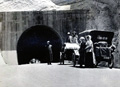
Rowher Flat encompasses approximately 9,600 acres with routes for a variety of OHV’s, including motorcycles, 4×4’s, dune buggies and all-terrain vehicles (ATV’s). There are approximately 45 miles of marked trails and three staging areas. Rowher Flat also offers a Kids Area loop trail, a 4×4 trials course, and 161 acres of open area for motorized vehicle recreation. The Forest recently completed a development grant for construction of new facilities at three staging areas within the Rowher Flat OHV Area.
Drinkwater Flat encompasses approximately 8,000 acres with 20 miles of routes for motorcycles, 4×4’s and ATV’s. A staging area with parking is provided to access the trail system. The 2002 Copper Fire burned the entirety of the Drinkwater Flat OHV Area; this planning project will include development of a Proposed Action that would address the Copper Fire damage issues.
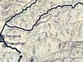
Directions to Rowher Flat Staging Area 1:
From California State Route 14 (North): take the Sierra HWY exit (Canyon Country); turn right onto Sierra HWY (continue for 7.5 miles); turn left on Rush Canyon Road and continue 2.8 miles.
From California State Route 14 (South): take exit Via Princessa; turn right at Via Princessa; turn right onto Sierra HWY (continue for 7.5 miles); turn left on Rush Canyon Road and continue 2.8 miles.
Like this:
Like Loading...
Related


 Tweet This
 Facebook
 Digg This
 Bookmark
 Stumble
 RSS
RSS


REAL NAMES ONLY: All posters must use their real individual or business name. This applies equally to Twitter account holders who use a nickname.
2 Comments
So…how do we find out what the ANF Ownership is planning to do to these sites? This press release is worthless if we cannot get a look at the initial plan before they close the gates and lock them after Sept. 30, 2019.
Trying to get to Arcadia for a 6pm meeting on a weekday afternoon is ridiculous given the traffic (and that’s without any major accidents).
Where is the online access to the preparatory documents/plans for the future usage of these sites in the ANF? Just because Congress doesn’t give a …hoot about user access to the National Forests, doesn’t mean that the understaffed and anti-use Management of the ANF should be allowed to do whatever they want with these lands. They are held by the US Government in perpetuity for the usage of All Americans, regardless of how little interest Congress has in funding this sliver of the U.S. Dept of Agriculture’s giant budget.
I feel sorry for the ANF’s employees; most of them would like to see reasonable use of the Forest lands they protect and serve. Instead, they are (at the highest levels) forced to choose between keeping the mining, lumber and Agricultural, and other high dollar usage well protected while citizen access to Forest lands is reduced to bus trips and walking paths.
Guess who wins?
Not us.
It’s even worse than I thought. I accessed the appropriate web page (after dodging the Flackbook page I was first directed to)and found that the ANF site doesn’t offer any more info than was in the press release you posted here.
That is correct; there is no information regarding plans, ideas, input from users or anything else of use posted on their webpage regarding plans for these two large and important sites for off-roading in the western part of the ANF.
In other words, they are planning to do something for some reason, and they don’t want anyone to know what it is until it is too late to have any input or effects on their plans.
I used to work in gov’t and I know what this means. It’s a slam-dunk before any other players know that the whistle has sounded to start play.
A “public comment” event on Aug. 22, a “field site visit” on Aug 24 (great, I get to decide if I want to attend the site visit or take my HHE Waste stuff to the Pick-up site at Via Princessa) and then the plans will be finalized on Sept. 30.
Gee, why bother even telling us?